Martha's Vineyard

Martha's Vineyard (and the smaller Chappaquiddick Island nearby) is an island off the southern coast of Cape Cod, both forming a part of the Outer Lands region. It is often called just "the Vineyard". With a land area of 87.48 square miles (231.75 km²), Martha's Vineyard is the 57th largest island in the United States. It is located in the U.S. state of Massachusetts, in Dukes County, which also includes Cuttyhunk and the other Elizabeth Islands, as well as the island of Nomans Land.

Grange Hall
West Tisbury
Gay Head Light
Aquinnah
Chappy Ferry
Edgartown


Coordinates: 41°24′N 70°37′W / 41.400°N 70.617°W
Martha's Vineyard Media

Aerial view of Martha's Vineyard with Elizabeth Islands above
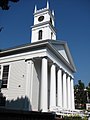
Old Whaling Church, Edgartown Village Historic District

Classicist house next to the Whaling Church

Gay Head Cliffs on Martha's Vineyard

Martha's Vineyard secession flag

Ocean Park bandstand, Oak Bluffs


