McLean County, Illinois
McLean County is the largest county by land area in the U.S. state of Illinois. According to the 2020 census, it had a population of 170,954.[1] Its county seat is Bloomington.[2]
| McLean County, Illinois | |
| Map | |
 Location in the state of Illinois | |
 Illinois's location in the U.S. | |
| Statistics | |
| Founded | December 25, 1830 |
|---|---|
| Seat | Bloomington |
| Largest City | Bloomington |
| Area - Total - Land - Water |
1,186 sq mi (3,072 km²) 1,183 sq mi (3,064 km²) 2.9 sq mi (8 km²), 0.2 |
| Population - Density |
|
| Time zone | Central: UTC-6/-5 |
| Website: http://www.mcleancountyil.gov/ | |
| Named for: John McLean | |
McLean County was founded in 1830 and named for John McLean, United States Senator for Illinois, who died in 1830.[3]
Geography
The county has a total area of 1,186 square miles (3,070 km2).
Bordering counties
- Woodford County - northwest
- Livingston County - northeast
- Ford County - east
- Champaign County - southeast
- Piatt County - south
- DeWitt County - south
- Logan County - southwest
- Tazewell County - west
Communities
Cities
Town
Villages
Census-designated place
Other unincorporated communities
- Barnes
- Bentown
- Bloomington Heights
- Cropsey
- Covell
- Funks Grove
- Holder
- Lyttleville
- Meadows
- Merna
- Shirley
- Watkins
- Weedman
- Weston
Townships
McLean County is divided into these townships:
Ghost towns
- Allin
- Benjaminville
- Kumler
McLean County, Illinois Media

Map of McLean County, Illinois
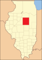
McLean County from the time of its creation to 1837

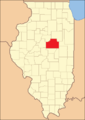
McLean County between 1837 and 1841
McLean County in 1841, reduced to its present borders


References
- ↑ "QuickFacts: McLean County, Illinois". United States Census Bureau. Retrieved August 14, 2023.
- ↑ "Find a County". National Association of Counties. Archived from the original on May 31, 2011. Retrieved 2011-06-07.
- ↑ Gannett, Henry (1905). The Origin of Certain Place Names in the United States. U.S. Government Printing Office. p. 194.