Mino Province

Lua error in Module:Unicode_data at line 293: attempt to index local 'data_module' (a boolean value)., one of the List of Provinces of Japan, encompassed part of modern-day Gifu Prefecture on the island of Honshū.[1] It was sometimes called Lua error in Module:Unicode_data at line 293: attempt to index local 'data_module' (a boolean value)..[2]
Mino had borders with Echizen, Hida, Ise, Mikawa, Ōmi, Owari, and Shinano Provinces.
The ancient capital city of the province was near Tarui. The main castle town was at Gifu.
History

In 713, the road crossing through Mino and Shinano provinces was widened to accommodate increasing numbers of travelers.[3]
In 1600, the Battle of Sekigahara took place at the western edge of Mino, near the mountains between the Chūbu region and the Kinki region.
In the Meiji period, the provinces of Japan were converted into prefectures. The maps of Japan and Mino Province were reformed in the 1870s.[4]
Shrines and Temples
Shitori jinja was the chief Shinto shrine (ichinomiya) of Mino. [5]
Mino Province Media
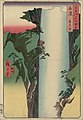
Hiroshige ukiyo-e "Hida" in "The Famous Scenes of the Sixty States" (六十余州名所図会), depicting a Yōrō Waterfalls

Related pages
References
- ↑ Nussbaum, Louis-Frédéric. (2005). "Mino" in Japan Encyclopedia, p. 638.
- ↑ Murdoch, James. (1903). A History of Japan, Vol. 3. p. 794.
- ↑ Titsingh, Isaac. (1834). Annales des empereurs du japon, p. 64.
- ↑ Nussbaum, "Provinces and prefectures" at p. 780.
- ↑ "Nationwide List of Ichinomiya," p. 2 Archived 2013-05-17 at the Wayback Machine; retrieved 2012-1-18.
Other websites
![]() Media related to Mino Province at Wikimedia Commons
Media related to Mino Province at Wikimedia Commons