Mont Aigoual
Mont Aigoual (Occitan: Mount Augal) is a French mountain in the Cévennes, a southern part of the Massif Central in the Occitanie region. It is on the border of the Lozère and Gard departments and is the highest mountain of Gard.
 East face of Mont Aigoua | |
| Elevation | 1,565 m (5,135 ft)[1] |
|---|---|
| Prominence | 732 m (2,402 ft)[1] |
| Location | |
| Location | Gard departement, France |
| Range | Massif Central |
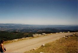
When the sky is clear, it is possible to see the Mediterranean Sea, the Pyrenees, and also the Alps and Mont Blanc in particular.
Name
The word "Aigoual" appears with different meanings: ad stratam Aigoaldi in 1228 refers to a route, marcha Algoaldi in 1238 names the limits of a territory, and mons Aigoaldi in 1249 is the name of the mountain. It seems that Aigoual comes from the word Algwarld, the name of a person in the region.[2]
Geography
Mont Aigoual has an elevation of 1,565 m (5,135 ft) and is the highest mountain in the Gard department and the second in the Lozère department and in the Cévennes mountains after Mont Lozère that is 1,699 m (5,574 ft) high. Mont Aigoual is within the Cévennes National Park (French: Parc national des Cévennes).
The summit of Mont Aigoual is on plateau with an altitude more than 1,500 m (4,900 ft) high and with an area of about 2 km2 (0.77 sq mi) in the communes Valleraugue (Gard) et Bassurels (Lozère). The watershed across the plateau divides the drainage basin in two: the Atlantic to the north and the Mediterranean to the south.
On its southern slopes is the source of the Hérault river, that flows to the south into the Mediterranean Sea.
The mountain is formed by granite from the Palaeozoic era.
On top of the mountain there is a meteorological station built in 1887. It is the last remaining weather station in France which is still inhabited by meteorologists. An exhibition on weather forecasting is open to visitors in the summer months.[3]

View of the Cévennes in Lozére
View to the northeast

View to the east, to Vaucluse

View to the sea


Climate
Mont Aigoual has an oceanic climate (Cfc), bordering to a subartic (Dfc) (highland) climate.

| Climate data for Mont Aigoual, France (altitude 1565m, 1981–2010) (Source: Météo-France) | |||||||||||||
|---|---|---|---|---|---|---|---|---|---|---|---|---|---|
| Month | Jan | Feb | Mar | Apr | May | Jun | Jul | Aug | Sep | Oct | Nov | Dec | Year |
| Average high °C (°F) | 1.0 (33.8) |
0.7 (33.3) |
3.0 (37.4) |
5.3 (41.5) |
9.7 (49.5) |
13.9 (57) |
17.3 (63.1) |
17.0 (62.6) |
13.0 (55.4) |
8.7 (47.7) |
4.2 (39.6) |
2.1 (35.8) |
7.99 (46.39) |
| Average low °C (°F) | -3.5 (25.7) |
-3.8 (25.2) |
-2.0 (28.4) |
0.0 (32) |
4.1 (39.4) |
7.7 (45.9) |
10.4 (50.7) |
10.4 (50.7) |
7.2 (45) |
4.1 (39.4) |
-0.4 (31.3) |
-2.6 (27.3) |
2.63 (36.74) |
| Precipitation mm (inches) | 175.4 (6.906) |
146.2 (5.756) |
109.3 (4.303) |
177.5 (6.988) |
159.7 (6.287) |
92.9 (3.657) |
48.3 (1.902) |
67.7 (2.665) |
175.4 (6.906) |
298.4 (11.748) |
282.0 (11.102) |
198.9 (7.831) |
1,931.7 (76.051) |
| Source: Météo France[4] | |||||||||||||
Sports
A well-known hiking route is the "Climbing of the 4,000 steps" that begins in Valleraugue and ends in the weather station.
The ski station (a place where people go to practice skiing) of Prat Peyrot is on the sides of the Aigoual. It is the biggest ski station of the Cévennes.
References
- ↑ 1.0 1.1 "Mont Aigoual, France". Peakbagger.com. Retrieved 11 January 2017.
- ↑ Mulon, Marianne (1963). "La forêt de l'Aigoual et l'origine de ce toponyme". Bulletin philologique et historique jusqu'à 1610 du Comité des travaux historiques et scientifiques (in français). 1: 57–64. Retrieved 11 January 2017.
- ↑ "Météo - Observatoire du Mont Aigoual" (in français). Station météo de Ferrals les Corbières. Archived from the original on 6 March 2016. Retrieved 11 January 2017.
- ↑ "Données climatiques de la station de Mont Aigoual" (in français). Meteo France. Archived from the original on 14 June 2020. Retrieved 11 January 2017.
Other websites
- Observatoire du Mont Aigoual website Archived 2020-08-18 at the Wayback Machine
- Office de tourisme Causses Aigoual Cévennes (in French)
- Prat Peyrot - Station de ski du Mont Aigoual website Archived 2016-12-02 at the Wayback Machine (in French)