Mont Mézenc
Mont Mézenc is a French mountain in the Massif du Mézenc, part of the Massif Central in the Auvergne-Rhône-Alpes region. It is on the border of the Ardèche and Haute-Loire departments and is the highest mountain of both departments.
 The two summits of Mont Mézenc : the northern summit to the left and the southern summit to the right. | |
| Elevation | 1,753 m (5,751 ft)[1] |
|---|---|
| Prominence | 793 m (2,602 ft)[1] |
| Location | |
| Location | Ardèche and Haute-Loire departments, France |
| Range | Massif Central |
| Climbing | |
| Easiest route | from Les Estables |
The mountain is in the "Natural regional park of the Mountains of Ardèche" (French: Parc naturel régional des Monts d'Ardèche).
Geography
Mont Mézenc is the highest mountain of the eastern border of the Massif Central.[2] It is formed by two summits that are separated for a distance of about 0.5 km (0.3 mi):
- The southern summit is the highest with an altitude of 1,753 m (5,751 ft); it is in the commune of Borée, Ardèche department, and is the highest point in this department.
- The northern summit has an altitude of 1,744 m (5,722 ft), where the communes La Rochette (Ardèche), Chaudeyrolles (Haute-Loire) and Les Estables (Haute-Loire) meet. It is the highest point of the Haute-Loire department. There is an iron cross on top of this summit; it was put there by French prisoners when they returned from Germany.
The Mont Mézenc has a volcanic origin; it is a dome of phonolite, a kind volcanic rock.[3] The mountain is covered by grasslands and heaths.
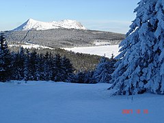
Mont Mézenc in winter.

Massif du Mézenc in the Massif Central.
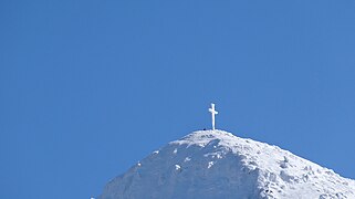
The cross on the summit.


Mont Mézenc Media

Mont Mézenc sommet sud : 1753 m / sommet nord :1749m, surmonté d'une croix.*Massif Central - France self made PRA
References
- ↑ 1.0 1.1 "Mont Mézenc, France". Peakbagger.com. Retrieved 29 September 2017.
- ↑ "Mont Mézenc (1753m)" (in français). altituderando. Retrieved 29 September 2017.
- ↑ "Le Mézenc - Mézenc et Gerbier, vacances randonnées sur le Chemin de Stevenson (GR70) : Mézenc Loire Sauvage". Mezencloiresauvage.com. Archived from the original on 21 July 2017. Retrieved 29 September 2017.
Other websites
- Un matin sur le mont chauve des Cévennes (in French)