Oberspreewald-Lausitz
Oberspreewald-Lausitz (Low Sorbian: Wokrejs Górne Błota-Łužyca) is a Kreis (district) in the southern part of Brandenburg, Germany.
 Flag  Coat of arms | |
 | |
| Country | |
| State | Brandenburg |
| Capital | Senftenberg |
| Area | |
| • Total | 1,216.6 km2 (469.7 sq mi) |
| Population (2002) | |
| • Total | 139,786 |
| • Density | 114.899/km2 (297.587/sq mi) |
| Time zone | UTC+1 (CET) |
| • Summer (DST) | UTC+2 (CEST) |
| Vehicle registration | OSL |
| Website | http://www.osl-online.de |
Geography
The Spree river runs through the district; along its banks there is the Spreewald, a wooded area and home of several rare animals. The district is part of the historic region of Lusatia.
History
The district was made in 1993 by joining the old districts Calau and Senftenberg and small part of the district Bad Liebenwerda.
Coat of arms
|
|
The coat of arms shows a red bull (the symbol of the Lower Lusatia region), for the former district Calau. The city wall in the bottom part is an old symbol of the Upper Lusatia region, and also represents the former district Senftenberg. The shield with a lion is the symbol of the county of Meißen. This is because the municipalities of the Bad Liebenwerda were part of the county. |
Towns and municipalities
| Amt-free towns | Ämter | |
|---|---|---|
|
|
1. Altdöbern 2. Ortrand |
3. Ruhland |
| 1seat of the Amt; 2town | ||
Oberspreewald-Lausitz Media

District banner of Oberspreewald-Lausitz
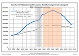
Development of Population since 1875 within the Current Boundaries (Blue Line: Population; Dotted Line: Comparison to Population Development of Brandenburg state)
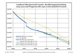
Recent Population Development and Projections (Population Development before Census 2011 (blue line); Recent Population Development according to the Census in Germany in 2011 (blue bordered line); Official projections for 2005-2030 (yellow line); for 2014-2030 (red line); for 2017-2030 (scarlet line)
References
Other websites
- Official website (in German)