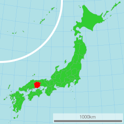
Okayama Prefecture
Lua error in Module:Unicode_data at line 293: attempt to index local 'data_module' (a boolean value). is a Japanese prefecture in the Chūgoku region of the island of Honshū.[1] The capital city is Okayama.[2]
| Okayama Prefecture | |||||||||
| |||||||||

| |||||||||
| Capital | Okayama (city) | ||||||||
| Region | Chūgoku | ||||||||
| Island | Honshū | ||||||||
| Governor | Masahiro Ishii | ||||||||
| Area (rank) | 7,112.32 km² (15th) | ||||||||
| - % water | 0.3% | ||||||||
| Population (October 2005) | |||||||||
| - Population | 1,957,056 (21st) | ||||||||
| - Density | 275 /km² | ||||||||
| Districts | 10 | ||||||||
| Municipalities | 27 | ||||||||
| ISO 3166-2 | JP-33 | ||||||||
| Website | www.pref.okayama.jp/ kikaku/kokusai/momo/e/ | ||||||||
| Prefectural Symbols | |||||||||
| - Flower | Peach blossom (Prunus persica var. vulgaris) | ||||||||
| - Tree | Red pine (Pinus densiflora) | ||||||||
| - Bird | Lesser cuckoo (Cuculus poliocephalus) | ||||||||
| - Fish | |||||||||
 Symbol of Okayama Prefecture | |||||||||
| Template ■ Discussion | |||||||||
History
During the Meiji Restoration, the area of Okayama Prefecture was known as Bitchū Province, Bizen Province and Mimasaka Province.[3]
Geography
Okayama Prefecture borders Hyōgo Prefecture its the west, Tottori Prefecture on its north and Hiroshima Prefecture on its east. It faces Kagawa Prefecture in Shikoku to the west across the Seto Inland Sea. The prefecture includes 90 islands.
Cities
There are 15 cities in Okayama Prefecture:
- Akaiwa
- Asakuchi
- Bizen
- Ibara
- Kurashiki
- Maniwa
- Mimasaka
- Niimi
- Okayama (capital)
- Setouchi
- Sōja
- Takahashi
- Tamano
- Tsuyama
National Parks
National Parks are established in about 11% of the total land area of the prefecture.[4]
Shrines and Temples
Kibitsuhiko jinja and Kibitsu jinja are the chief Shinto shrines (ichinomiya) in the prefecture.[5]
Related pages
References
- ↑ Nussbaum, Louis-Frédéric. (2005). "Okayama-ken" in Japan Encyclopedia, p. 745; "Chūgoku" at p. 127.
- ↑ Nussbaum, "Okayama" at p. 745.
- ↑ Nussbaum, "Provinces and prefectures" at p. 780.
- ↑ Japan Ministry of the Environment, "General overview of area figures for Natural Parks by prefecture"; retrieved 2012-3-13.
- ↑ "Nationwide List of Ichinomiya," p. 3; retrieved 2012-8-26.
Other websites
Media related to Okayama prefecture at Wikimedia Commons
- http://www.pref.okayama.jp/kikaku/kokusai/momo/e/ Archived 2003-02-02 at the Wayback Machine; (in Japanese)
- Official tourism site
Coordinates: 34°42′N 133°51′E / 34.700°N 133.850°E
