Périgueux
Périgueux (Occitan: Perigüers)[2] is a commune in the Nouvelle-Aquitaine region in southwestern France. It is the capital, prefecture, of the Dordogne department.
|
Périgueux | |

| |
| Périgueux town hall | |
.svg)
| |
| Administration | |
|---|---|
| Country | France |
| Region | Aquitaine |
| Department | Dordogne |
| Arrondissement | Périgueux |
| Canton | Périgueux-1 Périgueux-2 |
| Intercommunality | Le Grand Périgueux |
| Mayor | Antoine Audi[1] (2014–2020) |
| Statistics | |
| Elevation | 75–189 m (246–620 ft) (avg. 106 m/348 ft) |
| Land area1 | 9.82 km2 (3.79 sq mi) |
| Population2 | 30,069 (2014) |
| - Density | 3,062/km2 (7,930/sq mi) |
| INSEE/Postal code | 24322/ 24000 |
| Website | perigueux.fr |
| 1 French Land Register data, which excludes lakes, ponds, glaciers > 1 km² (0.386 sq mi or 247 acres) and river estuaries. | |
| 2 Population without double counting: residents of multiple communes (e.g., students and military personnel) only counted once. | |
Geography
Périgueux is in the centre of the Dordogne department, in the tourist region named as Périgord Blanc. The Isle river flows through the city.
The city is at about 68 km (42 mi) from Angoulême, 109 km (68 mi) from Limoges, 109 km (68 mi) from Agen, 109 km (68 mi) from Bordeaux and 100 km (62 mi) from Cahors.
The commune of Périgueux has an area of 9.82 km2 (3.79 sq mi) and its average altitude is 106 m (348 ft); at the city hall, the altitude is 90 m (300 ft).[3]

|
Périgueux is surrounded by the communes Château-l'Évêque, Champcevinel, Trélissac, Boulazac, Notre-Dame-de-Sanilhac, Coulounieix-Chamiers, Marsac-sur-l'Isle and Chancelade.
Climate
Périgueux has an oceanic climate with template summers (Köppen climate classification: Cfb).[4]
Population
The inhabitants of Périgueux are known, in French, as Pétrocoriens (women: Pétrocoriennes).[5] Another name for the inhabitants of Périgueux is Périgourdins.
With a population of 30,069 (2014),[6] Périgueux has a population density of 3,062 inhabitants/km2.
Evolution of the population in Périgueux

Périgueux forms, together with 8 other communes, the urban area of Périgueux with a population of 66,895 inhabitants (2013) and an area of 157.5 km2 (60.8 sq mi).[7] This urban area is the centre of the metropolitan area of Périgueux, formed by 55 communes with a population of 102,855 inhabitants (2013) and an area of 108.7 km2 (42.0 sq mi).[8]
Administration
Périgueux is a prefecture of the Dordogne and the capital of the arrondissement of Périgueux.
The commune is the administrative centre (French: chef-lieu) of two cantons
- Périgueux-1, formed with a part of Périgueux;[9] and
- Périgueux-2, formed with the remaining part of Périgueux.[10]
It is part of the intercommunality Le Grand Périgueux (French: Communauté d'agglomération Le Grand Périgueux).
Twin towns
Périgueux is twinned with:
Gallery

Saint Front cathedral.

Saint-Georges church.

Périgueux Theater Palace.

The Vésone tower.
.JPG)
.JPG)

.JPG)
Périgueux Media
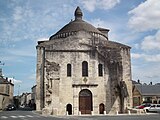
L'ancienne cathédrale Saint-Etienne de la Cité de Périgueux

The bell tower of St Front's cathedral
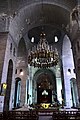
St Front's cathedral, inside


Related pages
References
- ↑ "Les élus" (in French). La Ville de Périgueux. Retrieved 11 March 2017.
{{cite web}}: CS1 maint: unrecognized language (link) - ↑ "Perigüers" (in French). Le nom occitan des communes du Périgord. Archived from the original on 3 March 2016. Retrieved 1 April 2015.
{{cite web}}: CS1 maint: unrecognized language (link) - ↑ "City of Périgueux". Map-France.com. Retrieved 1 April 2015.
- ↑ "Ville de Périgueux". Annuaire-Mairie.fr (in French). Retrieved 11 March 2017.
{{cite web}}: CS1 maint: unrecognized language (link) - ↑ "Périgueux (24000)" (in French). habitants.fr. Retrieved 1 April 2015.
{{cite web}}: CS1 maint: unrecognized language (link) - ↑ "Régions, départements, arrondissements, cantons et communes" (PDF). Populations légales 2014 (in French). Institut national de la statistique et des études économiques - INSEE. Retrieved 11 March 2017.
{{cite web}}: CS1 maint: unrecognized language (link) - ↑ "Unité urbaine de Périgueux (24501)". Comparateur de territoire (in French). Institut national de la statistique et des études économiques - INSEE. Retrieved 11 March 2017.
{{cite web}}: CS1 maint: unrecognized language (link) - ↑ "Aire urbaine de Périgueux (087)". Comparateur de territoire (in French). Institut national de la statistique et des études économiques - INSEE. Retrieved 11 March 2017.
{{cite web}}: CS1 maint: unrecognized language (link) - ↑ "Canton de Périgueux-1 (2414)". Géographie administrative et d’étude (in French). Institut national de la statistique et des études économiques - INSEE. Retrieved 11 March 2017.
{{cite web}}: CS1 maint: unrecognized language (link) - ↑ "Canton de Périgueux-2 (2415)". Géographie administrative et d’étude (in French). Institut national de la statistique et des études économiques - INSEE. Retrieved 11 March 2017.
{{cite web}}: CS1 maint: unrecognized language (link)
Other websites
| Wikivoyage has a travel guide about: Périgueux |
- Ville de Périgueux - Official site (in French)
- Office de Tourism, Périgueux Archived 2015-04-17 at the Wayback Machine
- Departamental Council of Dordogne (in French)
- Prefecture official website (in French)
- Région Nouvelle-Aquitaine (in French)