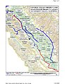
San Joaquin River

The San Joaquin River is one of the two major rivers of California, in the United States. At 330 miles (530 km) long, it is the second longest river in California, after the Sacramento River.[1] It begins on the west Sierra Nevada Mountains and flows west and north to its end at San Francisco Bay, at the Sacramento-San Joaquin Delta. Its basin, which is about 32,000 square miles (82,879 square kilometers) in size, contains mostly farmland. The river provides drinking water to over 22 million California citizens. Its three largest tributaries are the Merced, Tuolumne, and Stanislaus rivers.[2]
The river was once one of the richest river ecosystems in California. However, now over 60 miles (97 km) of the river is dry except during floods, because lots of water has been taken away for irrigation. In fact, below Friant Dam, a dam built in the 1940s on the San Joaquin River, 95 percent of the river's flow is dry. Much of the river is polluted, destroying the historic population of chinook salmon, once the southernmost in the United States. Pesticides, selenium, and many more toxic materials are carried by the San Joaquin into San Francisco Bay.[2]
Now, one of the largest projects in the American West has been begun to restore the San Joaquin River. On September 13, 2006, the Natural Resources Defense Council signed an agreement with Friant Dam users and the United States Department of the Interior. This agreement would restore the San Joaquin River below the dam, reducing pollution.[2]
Geography
Source in the Sierra Nevada

Three forks of the San Joaquin River join to form the San Joaquin River at two places, called Balloon Dome and Junction Butte.
- The North Fork (formally called the North Fork San Joaquin River) begins at a unnamed lake on the west side of the Sierra Nevada Mountains. This source is at coordinates 37°43′43″N 119°14′38″W / 37.7286°N 119.2440°W.[3] It is at 11,090 feet (3,380 m) above sea level, and is in Madera County.
- The Middle Fork (or the Middle Fork San Joaquin River) begins at a lake called Thousand Island Lake. This place is at coordinates 37°37′56″N 119°09′28″W / 37.6321°N 119.1579°W.[4]
- The South Fork (or the South Fork San Joaquin River) flows out of Martha Lake, at 11,004 feet (3,354 m) above sea level. Martha Lake is at coordinates 37°05′39″N 119°14′36″W / 37.0941°N 119.2434°W. The river is in Madera and Fresno counties.[5]
In the Central Valley
The river continues west into the Central Valley of California, and is joined by many other rivers flowing off the Sierra Nevada mountains. The most largest of these are the Stanislaus River, Tuolumne River, and Merced River. The Tuolumne and Merced river both flow out of Yosemite National Park.
As the river flows north and west, it is joined by the following tributaries:
- Mokelumne River
- Cosumnes River
- Calaveras River
- Stanislaus River
- Tuolumne River
- Merced River
- Bear Creek
- Hospital Creek
- Ingram Creek
- Chowchilla River
- Ash Slough
- Berenda Slough
- Fresno River
The San Joaquin River and its tributaries pass through/feed the following lakes and reservoirs:
- Pardee Reservoir
- Camanche Reservoir
- New Hogan Reservoir
- New Don Pedro Reservoir
- Lake McClure
- Eastman Lake
- Hensley Lake
- Mendota Pool
- Millerton Lake
- Pine Flat Reservoir
- Lake Kaweah
- Lake Success
- Florence Lake
- Mammoth Pool Reservoir
Several man-made channels are also part of the river system:
Mouth
The San Joaquin River eventually meets the Sacramento River, forming the Sacramento-San Joaquin Delta. This is one of the biggest estuaries in the United States. It is near the city of Antioch. At this place, the San Joaquin River splits into two rivers: the Old River and the Middle River. The Old River sometimes confuses fish to go down its channel. As a result, a wall is built between the San Joaquin River and the Old River.
Human impacts, economy, and development
Pre-development ecology
Before humans began to develop the Central Valley in the 1850s, the San Joaquin River and its surrounding lands were one of the richest biological habitats in California. In winter, the river would flood the valley, leaving behind wetlands. These wetlands became rich habitat for birds and other animals.[2] The habitat of the endangered San Joaquin Kit Fox and the riparian brush rabbit also was near the San Joaquin River.
Friant Dam: destroying life of the lower San Joaquin

In 1942, a big dam, Friant Dam, was built on the San Joaquin River. This dam took away a lot of water from the river, to irrigate crops, provide drinking water, and provide electricity. The dam destroyed the salmon habitat in the river, and also destroyed the creation of these wetlands.
The Friant Dam is:
The San Joaquin River has been used a lot for shipping of products via boats and ships, otherwise known as navigation. The river was first used for navigation during the California Gold Rush of 1849. Boats carried people over 200 miles (320 km) up the river to look for gold in the mountains. Now, there is a channel that runs all the way upriver to the city of Stockton. This channel allows big ships to sail in the river up to this point.[7] Sediment, however, has clogged a lot of the river channel above this point, preventing big ships from going any farther.
San Joaquin River Media

Crossings of California State Route 99 and the Union Pacific Railroad along the northern border of Fresno. The early stages of construction of California High-Speed Rail's San Joaquin River Viaduct is also visible.

The San Joaquin at Mendota Pool during the high flows of April 2006

Headwaters of the Middle Fork San Joaquin River, just downstream of Thousand Island Lake

Mariposa Indian Encampment by Albert Bierstadt, c. 1872

Mount Diablo (background), where Juan Crespí first gazed upon the Sacramento-San Joaquin Delta in 1772, with Suisun Bay in the foreground

Stockton, on the lower San Joaquin River, circa 1860, with the river to the left

An example of heavily irrigated farmland in the northern San Joaquin Valley, near Tracy and Manteca

Mammoth Pool Dam, the principal dam of the Big Creek Hydroelectric Project, completed in 1959

Stockton Deep Water Shipping Channel
Federal and state canals in the San Joaquin Valley


Notes
- ↑ "San Joaquin Basin: San Joaquin River". San Joaquin Basin. Archived from the original on 2009-03-26. Retrieved 2009-03-28.
- ↑ 2.0 2.1 2.2 2.3 "Restoring the San Joaquin River". Natural Resources Defense Council. Retrieved 2009-03-28.
- ↑ "North Fork San Joaquin River". United States Geographical Survey. Retrieved 2009-03-28.
- ↑ "Middle Fork San Joaquin River". United States Geographical Survey. Retrieved 2009-03-28.
- ↑ "South Fork San Joaquin River". United States Geographical Survey. Retrieved 2009-03-28.
- ↑ "Friant Dam". U.S. Bureau of Reclamation. Archived from the original on 2009-05-13. Retrieved 2009-03-28.
- ↑ "Mixing and Transport in the Stockton Deep Water Ship Channel". The Smithsonian/NASA Astrophysics Data System. Retrieved 2009-03-28.