South Dakota
South Dakota is a state in the United States. South Dakota became a state on November 2, 1889. Its capital is Pierre and largest city is Sioux Falls. Other important cities are Rapid City and Aberdeen. Famous attractions include Mount Rushmore, the Black Hills, and the Wall Drug Store. The Corn Palace is also famous, and it is in Mitchell. About 890,000 people lived there in 2020.
| State of South Dakota | |
|
| |
|
| |
| Anthem: Hail, South Dakota! | |
 Map of the United States with South Dakota highlighted | |
| Country | United States |
| Before statehood | Dakota Territory |
| Admitted to the Union | November 2, 1889 (39th or 40th) |
| Capital | Pierre |
| Largest city | Sioux Falls |
| Largest metro | Sioux Falls metropolitan area |
| Government | |
| • Governor | Kristi Noem (R) |
| • Lieutenant Governor | Larry Rhoden (R) |
| Legislature | South Dakota Legislature |
| • Upper house | Senate |
| • Lower house | House of Representatives |
| U.S. senators | John Thune (R) Mike Rounds (R) |
| U.S. House delegation | Dusty Johnson (R) (list) |
| Area | |
| • Total | 77,116 sq mi (199,729 km2) |
| • Land | 75,811 sq mi (196,350 km2) |
| • Water | 1,305 sq mi (3,379 km2) 1.7% |
| • Rank | 17th |
| Elevation | 2,200 ft (670 m) |
| Highest elevation | 7,244 ft (2,208 m) |
| Lowest elevation | 968 ft (295 m) |
| Population (2019) | |
| • Total | 884,659 |
| • Rank | 46th |
| • Density | 11.44/sq mi (4.42/km2) |
| • Rank | 46th |
| • Median household income | $56,521[4] |
| • Income rank | 30th |
| Language | |
| • Official language | English[5] • Sioux[6] |
| Time zones | |
| eastern half | UTC−06:00 (Central) |
| • Summer (DST) | UTC−05:00 (CDT) |
| western half | UTC−07:00 (Mountain) |
| • Summer (DST) | UTC−06:00 (MDT) |
| USPS abbreviation | SD |
| ISO 3166 code | US-SD |
| Trad. abbreviation | S.D., S.Dak. |
| Latitude | 42°29′ N to 45°56′ N |
| Longitude | 96°26′ W to 104°03′ W |
| Website | sd |
| South Dakota state symbols | |
|---|---|
 | |
 | |
| Living insignia | |
| Bird | Ring-necked pheasant |
| Fish | Walleye |
| Flower | American Pasque flower |
| Grass | Western wheat grass |
| Insect | Western honeybee |
| Mammal | Coyote |
| Tree | Black Hills Spruce |
| Inanimate insignia | |
| Beverage | Milk |
| Dance | Square dance |
| Fossil | Triceratops |
| Gemstone | Fairburn agate |
| Rock | Rose quartz |
| Soil | Houdek |
| Other | Kuchen (state dessert) |
| State route marker | |
 | |
| Lists of United States state symbols | |
South Dakota is bordered to the north by North Dakota, to the south by Nebraska, to the east by Iowa and Minnesota, and to the west by Wyoming and Montana.
There are nine Native American tribes that live in South Dakota.
South Dakota Media
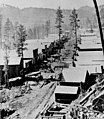
Deadwood, like many other Black Hills towns, was founded after the discovery of gold.

A harvest in South Dakota, 1898

A South Dakota farm during the Dust Bowl, 1936. Normal tilling practices turn South Dakota's fragile soil into a fine, loose powder that blows away, and sometimes covered vehicles, equipment, and buildings with dust during the Dust Bowl.

Terrain and primary geographic features of South Dakota

The Black Hills, a low mountain range, is located in Southwestern South Dakota.

Much of western South Dakota is covered by buttes.
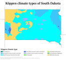
Köppen climate types in South Dakota

Mount Rushmore in the Black Hills

South Dakota population density map


.jpg)

Related pages
References
- ↑ "Black Elk Peak". NGS data sheet. U.S. National Geodetic Survey. http://www.ngs.noaa.gov/cgi-bin/ds_mark.prl?PidBox=OT0810. Retrieved 15 August 2016.
- ↑ 2.0 2.1 "Elevations and Distances in the United States". United States Geological Survey. 2001. Archived from the original on November 9, 2013. Retrieved January 19, 2016.
- ↑ 3.0 3.1 Elevation adjusted to North American Vertical Datum of 1988.
- ↑ "Median Annual Household Income". The Henry J. Kaiser Family Foundation. Archived from the original on December 20, 2016. Retrieved December 9, 2016.
- ↑ "South Dakota Codified Laws (1–27–20)". South Dakota State Legislature. Archived from the original on January 21, 2016. Retrieved January 19, 2016.
- ↑ "South Dakota recognizes official indigenous language". Argus Leader. Retrieved March 26, 2019.
Other websites
- The Official Home Page of South Dakota Archived 2007-07-26 at the Wayback Machine