Tango Province

Lua error in Module:Unicode_data at line 293: attempt to index local 'data_module' (a boolean value). was an old province in the area of Kyoto Prefecture on the island of Honshū.[1] Along with Tamba Province, it was sometimes called Lua error in Module:Unicode_data at line 293: attempt to index local 'data_module' (a boolean value)..
The province had borders with Tajima, Tamba, and Wakasa provinces.
Maizuru or Miyazu was the capital city of the province.
History
_-_Utagawa_Hiroshige_(Ando).jpg)
In 713 (Wadō 6, 3rd month), Tango was separated from Tamba province.[2]
In the Meiji period, the provinces of Japan were converted into prefectures. The maps of Japan and Tango Province were reformed in the 1870s.[3]
Geography
Tango faced the Sea of Japan.
Shrines and Temples
Kono jinja was the chief Shinto shrine (ichinomiya) of Tango.[4]
Tango Province Media
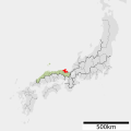
Map of Japanese provinces (1868) with Tango Province highlighted

Hiroshige ukiyo-e "Tango" in "The Famous Scenes of the Sixty States" (六十余州名所図会), depicting Ama-no-Hashidate


Related pages
References
- ↑ Nussbaum, Louis-Frédéric. (2005). "Tango" in Japan Encyclopedia, p. 948.
- ↑ Titsingh, Isaac. (1834). Annales des empereurs du Japon, p. 64.
- ↑ Nussbaum, "Provinces and prefectures" at p. 780.
- ↑ "Nationwide List of Ichinomiya," p. 2 Archived 2013-05-17 at the Wayback Machine; retrieved 2012-1-17.
Other websites
![]() Media related to Tango Province at Wikimedia Commons
Media related to Tango Province at Wikimedia Commons