File:2010 Chile earthquake epicenter.png
No higher resolution available.
2010_Chile_earthquake_epicenter.png (269 × 589 pixels, file size: 112 KB, MIME type: image/png)
| This is a file from the Wikimedia Commons. The description on its description page there is shown below.
|
| Description |
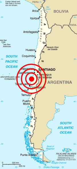
Deutsch: Karte von Chile aus dem CIA World Factbook mit dem Epizentrum des Erdbebens 2010 Chile
Español: Mapa de Chile de la CIA World Factbook, con el epicentro del terremoto de Chile 2010
Français : Carte du Chili de la CIA World Factbook avec l'épicentre du tremblement de terre du Chili 2010
Português: Mapa do Chile da CIA World Factbook, com o epicentro do terremoto do Chile em 2010 |
| Date | (original); 2010-02-27 (This image) |
| Source | Originally from Central Intelligence Agency's World Factbook. Location of epicenter from BBC |
| Author | Central Intelligence Agency's World Factbook |
| Permission (Reusing this file) |
PD-USGOV-CIA-WF. |
Licensing
This image is in the public domain because it contains materials that originally came from the United States Central Intelligence Agency's World Factbook.
|
 |
| Annotations | This image is annotated: View the annotations at Commons |
File history
Click on a date/time to view the file as it appeared at that time.
| Date/Time | Dimensions | User | Comment | |
|---|---|---|---|---|
| current | 06:45, 27 February 2010 | 269 × 589 (112 KB) | Cargoking | {{Information |Description=Map of en:Chile from [http://www.lib.utexas.edu/maps/cia02/chile_sm02.gif CIA World Factbook] with the epicenter of 2010 Chile earthquake marked. |Source=Originally from Central Intelligence Agen |
File usage
The following page uses this file: