File:Ancient Japan provinces map.jpg

Original file(800 × 1,129 pixels, file size: 168 KB, MIME type: image/jpeg)

Commons-logo.svg This is a file from the Wikimedia Commons. The description on its description page there is shown below.
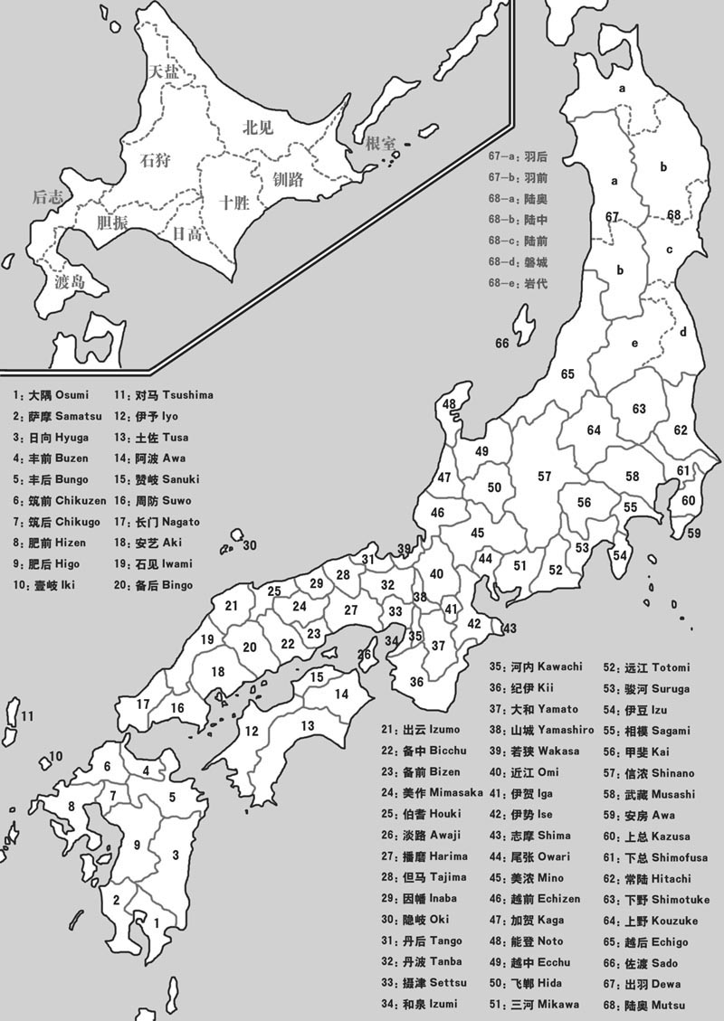
Commons is a freely licensed media file repository. You can help.
Description Ancient provinces of Japan
Date
Source created by Wikipedia user, based on 最新高等日本地图,
Author user:kallgan
Permission
(Reusing this file)
GNU head Permission is granted to copy, distribute and/or modify this document under the terms of the GNU Free Documentation License, Version 1.2 or any later version published by the Free Software Foundation; with no Invariant Sections, no Front-Cover Texts, and no Back-Cover Texts. A copy of the license is included in the section entitled GNU Free Documentation License.
w:en:Creative Commons
attribution share alike
This file is licensed under the Creative Commons Attribution-Share Alike 3.0 Unported license.
You are free:
  • to share – to copy, distribute and transmit the work
  • to remix – to adapt the work
Under the following conditions:
  • attribution – You must give appropriate credit, provide a link to the license, and indicate if changes were made. You may do so in any reasonable manner, but not in any way that suggests the licensor endorses you or your use.
  • share alike – If you remix, transform, or build upon the material, you must distribute your contributions under the same or compatible license as the original.
This licensing tag was added to this file as part of the GFDL licensing update.
Other versions


This historical map image could be re-created using vector graphics as an SVG file. This has several advantages; see Commons:Media for cleanup for more information. If an SVG form of this image is available, please upload it and afterwards replace this template with {{vector version available|new image name}}.


It is recommended to name the SVG file “Ancient Japan provinces map.svg”—then the template Vector version available (or Vva) does not need the new image name parameter.

Original map created on May 28 2005, as illustration of article "Meiji restoration and the rising of Imperial Japanese Army", War History Studies Volume I (ISBN 720404651X), size modified before uploaded

Captions

Add a one-line explanation of what this file represents

Items portrayed in this file

depicts

27 April 2006

image/jpeg

7315521f9989a3072a31bccb3185a2cfd3f99324

172,429 byte

1,129 pixel

800 pixel

File history

Click on a date/time to view the file as it appeared at that time.

Date/TimeDimensionsUserComment
current07:09, 4 January 2010800 × 1,129 (168 KB)うぃき野郎{{Information| |Description=Ancient provinces of Japan |Source=created by Wikipedia user, based on 最新高等日本地图, |Date=2006-04-27 |Author=user:kallgan |Permission={{GFDL|migration=relicense}} |other_versions=[[:Ancient Japan provinces map

There are no pages that use this file.

Metadata