File:Aquila chrysaetos distribution map.png

Size of this preview: 800 × 370 pixels. Other resolutions: 320 × 148 pixels | 640 × 296 pixels | 1,357 × 628 pixels.
Original file (1,357 × 628 pixels, file size: 39 KB, MIME type: image/png)
| This is a file from the Wikimedia Commons. The description on its description page there is shown below.
|
Summary
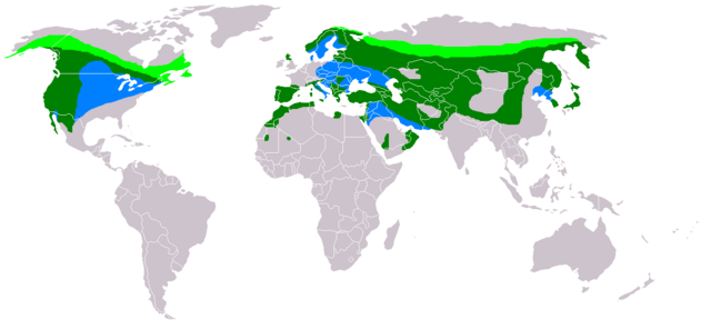
Español: Distribución del águila real en el mundo. Zonas de cría (verde claro), hibernación (azul) y ocupación sedentaria (verde oscuro).
Summary
| Description |
العربية: انتشار Aquila chrysaetos
الأخضر الغامق - الموئل الدائم.
الأخضر الفاتح - زائر للتعشيش.
الأزرق - زائر شتويّ. Български: Ареал на Aquila chrysaetos
район на гнездене район на уседнал начин на живот (не напускат района целогодишно) район на зимуване Español: Distribución de Aquila chrysaetos
área de incubación área de ocupación sedentaria área de invernación Français : Répartition géographique de Aquila chrysaetos
nidification habitat permanent zone d'hivernage Italiano: Areale della Aquila chrysaetos
area di riproduzione stanziale durante l'anno migrazione invernale മലയാളം: Aquila chrysaetos വംശത്തിന്റെ വിതരണം
കൂടുകൂട്ടുന്ന പ്രദേശങ്ങൾ എല്ലാക്കാലത്തും കാണുന്ന പ്രദേശങ്ങൾ ശീതകാലം കഴിച്ചുകൂട്ടുന്ന പ്രദേശങ്ങൾ Nederlands: Leefgebied van de Aquila chrysaetos
broedgebied permanent leefgebied overwinteringsgebied Polski: Zasięg występowania Aquila chrysaetos
zasięg gniazdowania zasięg występowania przez cały rok zasięg zimowania |
| Date | |
| Source | |
| Author | The Engineer |
Licensing:

|
Permission is granted to copy, distribute and/or modify this document under the terms of the GNU Free Documentation License, Version 1.2 or any later version published by the Free Software Foundation; with no Invariant Sections, no Front-Cover Texts, and no Back-Cover Texts. A copy of the license is included in the section entitled GNU Free Documentation License. |
| This file is licensed under the Creative Commons Attribution-Share Alike 3.0 Unported license. | ||
| ||
| This licensing tag was added to this file as part of the GFDL licensing update. |
This image has been categorised by project WikiProject Birds
File history
Click on a date/time to view the file as it appeared at that time.
| Date/Time | Dimensions | User | Comment | |
|---|---|---|---|---|
| current | 08:34, 9 March 2018 | 1,357 × 628 (39 KB) | Maphobbyist | Montenegro and South Sudan borders |
File usage
The following page uses this file: