File:Arrondissement Waremme Belgium Map.png
No higher resolution available.
Arrondissement_Waremme_Belgium_Map.png (290 × 220 pixels, file size: 5 KB, MIME type: image/png)
| This is a file from the Wikimedia Commons. The description on its description page there is shown below.
|
Summary
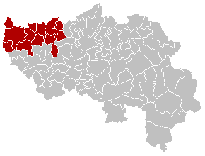
English: Map of Waremme District in province of Liège, Belgium
Français : Carte indiquant la localisation de l'arrondissement de Waremme dans la Province de Liège.
Walon : Mape des comenes del province di Lidje, avou l' arondixhmint d' Wareme e rodje.

|
File:Arrondissement Waremme Belgium Map.svg is a vector version of this file. It should be used in place of this PNG file when not inferior.
File:Arrondissement Waremme Belgium Map.png → File:Arrondissement Waremme Belgium Map.svg
For more information, see Help:SVG. |
 |
Licensing
| This work has been released into the public domain by its author, LennartBolks. This applies worldwide. In some countries this may not be legally possible; if so: |
File history
Click on a date/time to view the file as it appeared at that time.
| Date/Time | Dimensions | User | Comment | |
|---|---|---|---|---|
| current | 06:05, 24 September 2005 | 290 × 220 (5 KB) | Srtxg | EN; Map of Waremme District in province of Liège, Belgium FR; Carte indiquant la localisation de l'arrondissement de Waremme dans la Province de Liège. WA; Mape des comenes del province di Lidje, avou l' arondixhmint d' Wareme e rodje. [[Category:Map |
File usage
The following page uses this file: