File:Azores old map.jpg

Size of this preview: 800 × 563 pixels. Other resolutions: 320 × 225 pixels | 640 × 450 pixels | 1,024 × 720 pixels | 1,280 × 900 pixels | 2,104 × 1,480 pixels.
Original file (2,104 × 1,480 pixels, file size: 678 KB, MIME type: image/jpeg)
| This is a file from the Wikimedia Commons. The description on its description page there is shown below.
|
Summary

|
This old map image could be re-created using vector graphics as an SVG file. This has several advantages; see Commons:Media for cleanup for more information. If an SVG form of this image is available, please upload it and afterwards replace this template with
{{vector version available|new image name}}.
It is recommended to name the SVG file “Azores old map.svg”—then the template Vector version available (or Vva) does not need the new image name parameter. |
 | This old map image was uploaded in the JPEG format even though it consists of non-photographic data. This information could be stored more efficiently or accurately in the PNG or SVG format. If possible, please upload a PNG or SVG version of this image without compression artifacts, derived from a non-JPEG source (or with existing artifacts removed). After doing so, please tag the JPEG version with {{Superseded|NewImage.ext}} and remove this tag. This tag should not be applied to photographs or scans. If this image is a diagram or other image suitable for vectorisation, please tag this image with {{Convert to SVG}} instead of {{BadJPEG}}. If not suitable for vectorisation, use {{Convert to PNG}}. For more information, see {{BadJPEG}}. |
| DescriptionAzores old map.jpg |
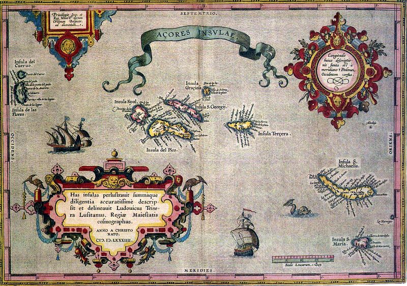
English: Sixteenth-century map of Azores. Legend, in Latin: "Has insulas perlustrauit summàque diligentia accuratissimè descripsit et delineauit Ludovicus Teisera Lusitanus, Regiæ Maiestatis cosmographus. ANNO A CHRISTO NATO, M.D.LXXXIIII" ("These islands were illustrated and described with great diligence and drawn by the Portuguese Luís Teixeira, his royal majesty's cartographer, AD 1584.")
Deutsch: alte Karte der Azoren
Português: "Açores Insulae" ("Ilhas dos Açores"), Luís Teixeira, c. 1584. A legenda, em latim - "Has insulas perlustrauit summàque diligentia accuratissimè descripsit et delineauit Ludovicus Teisera Lusitanus, Regiæ Maiestatis cosmographus. ANNO A CHRISTO NATO, M.D.LXXXIIII" -, pode ser traduzida livremente como: "Estas ilhas foram percorridas com a maior diligência, e com todo o cuidado as descreveu o português Luís Teixeira, cosmógrafo da Majestade Real. Ano do nascimento de Cristo de 1584." |
| Date | |
| Source | see above |
| Author | Abraham Ortelius |
Licensing
|
This is a faithful photographic reproduction of a two-dimensional, public domain work of art. The work of art itself is in the public domain for the following reason:
The official position taken by the Wikimedia Foundation is that "faithful reproductions of two-dimensional public domain works of art are public domain".
This photographic reproduction is therefore also considered to be in the public domain in the United States. In other jurisdictions, re-use of this content may be restricted; see Reuse of PD-Art photographs for details. | |||||
Captions
Add a one-line explanation of what this file represents
Items portrayed in this file
depicts
image/jpeg
4f86629470cba509ca83c7fad3ea4378f497531e
693,934 byte
1,480 pixel
2,104 pixel
File history
Click on a date/time to view the file as it appeared at that time.
| Date/Time | Dimensions | User | Comment | |
|---|---|---|---|---|
| current | 22:59, 16 July 2005 | 2,104 × 1,480 (678 KB) | Nataraja~commonswiki |
File usage
The following page uses this file:
Retrieved from "https://wiki.kidzsearch.com/wiki/File:Azores_old_map.jpg"
