File:Belle Fourche River 19A.JPG
Size of this preview: 800 × 533 pixels. Other resolutions: 320 × 213 pixels | 640 × 427 pixels | 849 × 566 pixels.
Original file (849 × 566 pixels, file size: 316 KB, MIME type: image/jpeg)
| This is a file from the Wikimedia Commons. The description on its description page there is shown below.
|
Summary
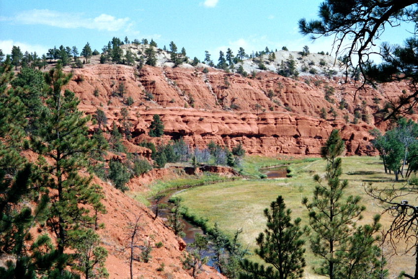
Belle Fourche River
- Description: Pinus ponderosa on dark red sandstone and maroon siltstone, interbedded with shale (not visible), along the Belle Fourche River, Spearfish Formation, Triassic. The greyish beds visible on top belong to the overlying Gypsum Spring Formation, Jurassic.
- Viewpoint location: Red Beds Trail 300 meters north of the Highway 110 bridge across the Belle Fourche River, Devils Tower National Monument
| Camera location | | View this and other nearby images on: OpenStreetMap |
|---|
- Viewpoint elevation: 3940 ft.
- View direction: Northeast
- Date and time: 2000.09.09 late morning
- Camera: Olympus 35 mm film
- Photographer: Walter Siegmund
©2005 Walter Siegmund
Licensing
I, the copyright holder of this work, hereby publish it under the following licenses:

|
Permission is granted to copy, distribute and/or modify this document under the terms of the GNU Free Documentation License, Version 1.2 or any later version published by the Free Software Foundation; with no Invariant Sections, no Front-Cover Texts, and no Back-Cover Texts. A copy of the license is included in the section entitled GNU Free Documentation License. |
| This file is licensed under the Creative Commons Attribution-Share Alike 3.0 Unported license. | ||
| ||
| This licensing tag was added to this file as part of the GFDL licensing update. |
This file is licensed under the Creative Commons Attribution 2.5 Generic license.
- You are free:
- to share – to copy, distribute and transmit the work
- to remix – to adapt the work
- Under the following conditions:
- attribution – You must give appropriate credit, provide a link to the license, and indicate if changes were made. You may do so in any reasonable manner, but not in any way that suggests the licensor endorses you or your use.
You may select the license of your choice.
File history
Click on a date/time to view the file as it appeared at that time.
| Date/Time | Dimensions | User | Comment | |
|---|---|---|---|---|
| current | 19:08, 15 November 2005 | 849 × 566 (316 KB) | Wsiegmund | '''Belle Fourche River''' * '''Description:''' Pinus ponderosa on dark red sandstone and maroon siltstone, interbedded with shale (not visible), along the Belle Fourche River * '''Viewpoint location:''' Red Beds Trail 300 meters north of the Highway 1 |
File usage
The following page uses this file: