File:CIA map Central America & Caribbean.png

Size of this preview: 798 × 599 pixels. Other resolutions: 320 × 240 pixels | 639 × 480 pixels | 799 × 600 pixels | 1,023 × 768 pixels | 1,280 × 961 pixels | 1,390 × 1,044 pixels.
Original file (1,390 × 1,044 pixels, file size: 1.6 MB, MIME type: image/png)
| This is a file from the Wikimedia Commons. The description on its description page there is shown below.
|
JAY TAMBU MAYALA ENGANGE PAR LA CIA
Summary
| Description |
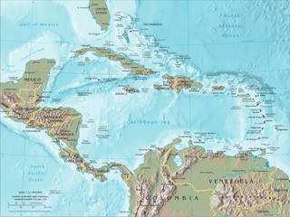
English: Map of Central America and the Caribbean by the CIA World Factbook Español: Mapa de Centroamérica y el Caribe en el CIA World Factbook |
| Source | Transferred from en.wikipedia to Commons. Original source is/was CIA The World Factbook |
| Author | U.S. Central Intelligence Agency (CIA) |
| Other versions |


Licensing
This image is in the public domain because it contains materials that originally came from the United States Central Intelligence Agency's World Factbook.
|
 |
Original upload log
The original description page was here. All following user names refer to en.wikipedia.
- 2007-09-20 19:45 Brianski 1392×1066×8 (1720810 bytes) == Summary == Map of [[Central America]], see https://www.cia.gov/library/publications/the-world-factbook/docs/refmaps.html. == License == {{PD-USGov-CIA-WF}}
File history
Click on a date/time to view the file as it appeared at that time.
| Date/Time | Dimensions | User | Comment | |
|---|---|---|---|---|
| current | 15:22, 10 June 2010 | 1,390 × 1,044 (1.6 MB) | Jahoe | better compression (no visible alterations) |
File usage
The following page uses this file: