File:Cold War alliances mid-1975.svg

Size of this PNG preview of this SVG file: 800 × 409 pixels. Other resolutions: 320 × 164 pixels | 640 × 327 pixels | 1,024 × 524 pixels | 1,280 × 655 pixels | 860 × 440 pixels.
Original file (SVG file, nominally 860 × 440 pixels, file size: 1.36 MB)
| This is a file from the Wikimedia Commons. The description on its description page there is shown below.
|
Summary
| Description |
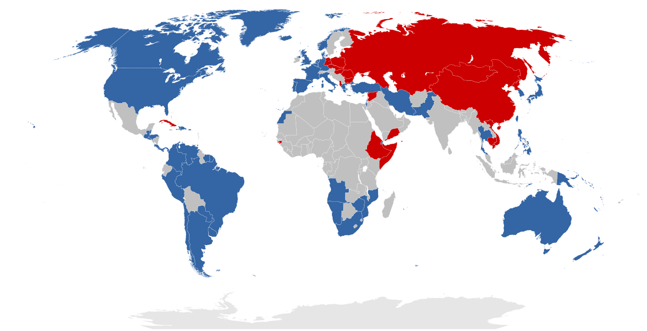
Dansk: Et simplificeret kort over den Kolde Krigs alliancer, som de så ud mellem 30. april og 24. juni 1975. De sovjetiske og kinesiske blokke er gruppet sammen af illustrative årsager, men under den repræsenterede tidsperiode var de ikke allierede. Den grå region udgjorde ikke en alliance, men indeholder derimod alle de lande, der ikke var allierede med Sovjetunionen, USA, eller Kina. Dette kort er baseret på File:First second third worlds map.svg, men er ændret til at vise en gruppering af lande der kan bekræftes og præcist afspejler titen af GFS [1].
English: A simplified map of the Cold War alliances between 30 April and 24 June 1975. The Soviet and Chinese blocs are grouped together as one for illustrative purposes, but note that historically they were not allied during the time represented. The grey region does not represent an alliance, but rather encompasses all countries that were not aligned with the Soviet Union, the USA, or China. This map is based on File:First second third worlds map.svg, but it is modified to display a grouping of countries that is verifiable and accurately reflects the caption of Three Worlds.
Rationale:
Eastern-aligned:
Nederlands: Een vereenvoudigde kaart van de bondgenootschappen tussen 30 april en 24 juni 1975. De Sovjet en Chinese blokken zijn gegroepeerd voor illustratieve doeleinden, maar merk op dat, historisch gezien, ze geen bondgenootschap hadden in die tijdsperiode. De grijs regio stelt geen bondgenootschap voor, maar voegt eerder alle landen samen die geen banden hadden met de Sovjet-Unie, de VS of China. Deze kaart is gebaseerd op File:First second third worlds map.svg, maar ze is aangepast om de landen weer te geven die tot de Eerste, Tweede of Derde Wereld behoren [2]. |
| Date | |
| Source | Own work |
| Author | Vorziblix |
Licensing
I, the copyright holder of this work, hereby publish it under the following license:
| This file is made available under the Creative Commons CC0 1.0 Universal Public Domain Dedication. | |
| The person who associated a work with this deed has dedicated the work to the public domain by waiving all of their rights to the work worldwide under copyright law, including all related and neighboring rights, to the extent allowed by law. You can copy, modify, distribute and perform the work, even for commercial purposes, all without asking permission.
|
File history
Click on a date/time to view the file as it appeared at that time.
| Date/Time | Dimensions | User | Comment | |
|---|---|---|---|---|
| current | 11:53, 1 December 2023 | 860 × 440 (1.36 MB) | Human Transistor | Guinea-Bissau and Cambodia were colored red. They were Communist states at this time. |
File usage
The following 3 pages use this file: