File:Dawn in Puerto Encantado.jpg

Original file (5,997 × 2,229 pixels, file size: 5.55 MB, MIME type: image/jpeg)
| This is a file from the Wikimedia Commons. The description on its description page there is shown below.
|
Summary
| Description |
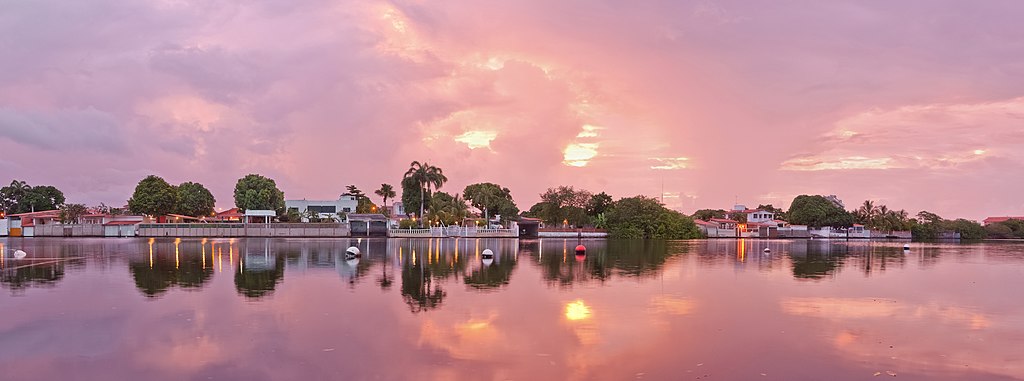
English: Panoramic view of Puerto Encantado (Enchanted Dock) at Dawn (time: 05:35 a.m.), in the town of Higuerote, Venezuela.
Español: Vista panorámica de la urbanización Puerto Encantado al amanecer (hora: 05:35 a.m.), en pueblo de Higuerote, en Venezuela.
Français : Vue panoramique sur Puerto Encantado (Trad.: « le port enchanté »), à Higuerote, au Vénézuela, prise à l'aube (05h35).
Русский: Панорамный вид на локацию Пуэрто-Энкантадо, снятый на рассвете (05:35 утра) в городе Игуэроте, субрегион Барловенто, штат Миранда, Венесуэла.
Українська: Панорама Пуерто Енкантадо (Зачарований док) на світанку (час: 05:35 ранку), у місті Гігероте, Венесуела.
|
|||
| Date | ||||
| Source | Own work | |||
| Author | Paolo Costa Baldi | |||
| Permission (Reusing this file) |
|
| Camera location | | View this and other nearby images on: OpenStreetMap |
|---|
| Camera Model | Nikon D90 |
|---|---|
| Lens | Nikon AF-S DX Nikkor 18-105mm f/3.5-5.6G ED VR |

|
NOTE: This image is a panorama consisting of multiple frames that were merged or stitched in software. As a result, this image necessarily underwent some form of digital manipulation. These manipulations may include blending, blurring, cloning, and colour and perspective adjustments. As a result of these adjustments, the image content may be slightly different from reality at the points where multiple images were combined. This manipulation is often required due to lens, perspective, and parallax distortions.
|
Assessment
|
This image was selected as picture of the day on Wikimedia Commons for 19 February 2024. It was captioned as follows: English: Panoramic view of Puerto Encantado (“Enchanted Dock”) at dawn in the town of Higuerote, Venezuela Other languages:
Čeština: Panoramatický pohled na přístav Puerto Encantado při svítání ve městě Higuerote, Venezuela. Deutsch: Puerto Encantado („Verzauberter Hafen“) in Higuerote, Venezuela am Morgen English: Panoramic view of Puerto Encantado (“Enchanted Dock”) at dawn in the town of Higuerote, Venezuela Français : Vue matinale du Puerto Encantado ("Port Enchanté") de la ville d'Higuerote (Venezuela). Nederlands: Puerto Encantado ('betoverde haven') van Higuerote, de hoofdplaats van de gemeente Brión in de Venezolaanse deelstaat Miranda Português: Vista panorâmica de Puerto Encantado ao amanhecer, em Higuerote, Venezuela. Slovenščina: Panoramski pogled na Puerto Encantado (»Začarani pristan«) ob zori v mestu Higuerote, Venezuela Македонски: Панорама на Пуерто Енкантадо („Маѓепсано пристаниште“) во Игероте, Венецуела. Русский: Панорамный вид на локацию Пуэрто-Энкантадо (исп. Puerto Encantado) в городе Игуэроте, субрегион Барловенто, штат Миранда, Венесуэла. Город привлекает туристов пляжами, лагунами, каналами, торговыми центрами и располагается примерно в 100 километрах от Каракаса Українська: Панорама Пуерто Енкантадо (Зачарований док) на світанку (час: 05:35 ранку), у місті Гігероте, Венесуела. |
Licensing
- You are free:
- to share – to copy, distribute and transmit the work
- to remix – to adapt the work
- Under the following conditions:
- attribution – You must give appropriate credit, provide a link to the license, and indicate if changes were made. You may do so in any reasonable manner, but not in any way that suggests the licensor endorses you or your use.
- share alike – If you remix, transform, or build upon the material, you must distribute your contributions under the same or compatible license as the original.

|
Permission is granted to copy, distribute and/or modify this document under the terms of the GNU Free Documentation License, Version 1.2 or any later version published by the Free Software Foundation; with no Invariant Sections, no Front-Cover Texts, and no Back-Cover Texts. A copy of the license is included in the section entitled GNU Free Documentation License. |
File history
Click on a date/time to view the file as it appeared at that time.
| Date/Time | Dimensions | User | Comment | |
|---|---|---|---|---|
| current | 23:18, 17 December 2011 | 5,997 × 2,229 (5.55 MB) | Paolostefano1412 | {{Information |Description ={{en|1=a}} {{es|1=s}} {{it|1=d}} |Source ={{own}} |Author =Paolostefano1412 |Date = |Permission = |other_versions = }} Category:Venezuela Category:Higuerote [[ |
File usage
The following page uses this file: