File:Deutschesreich1939.png

Size of this preview: 764 × 600 pixels. Other resolutions: 306 × 240 pixels | 612 × 480 pixels | 979 × 768 pixels | 1,032 × 810 pixels.
Original file (1,032 × 810 pixels, file size: 262 KB, MIME type: image/png)
| This is a file from the Wikimedia Commons. The description on its description page there is shown below.
|
| Description |
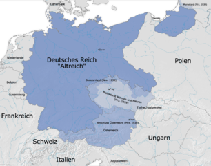
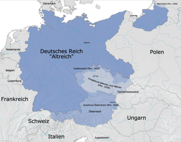
Deutsch: Die Grenzen des Deutschen Reiches (Altreich) am 31. 12. 1937 und Ausdehnungen 1938/1939 |
||
| Source | Own work and Demis | ||
| Author | FJ-de | ||
| Permission (Reusing this file) |
|
||
| Other versions |
.png)

|
This historical map image could be re-created using vector graphics as an SVG file. This has several advantages; see Commons:Media for cleanup for more information. If an SVG form of this image is available, please upload it and afterwards replace this template with
{{vector version available|new image name}}.
It is recommended to name the SVG file “Deutschesreich1939.svg”—then the template Vector version available (or Vva) does not need the new image name parameter. |
File history
Click on a date/time to view the file as it appeared at that time.
| Date/Time | Dimensions | User | Comment | |
|---|---|---|---|---|
| current | 04:40, 3 October 2009 | 1,032 × 810 (262 KB) | NordNordWest |
File usage
The following page uses this file: