File:Essex 2.svg

Size of this PNG preview of this SVG file: 800 × 549 pixels. Other resolutions: 320 × 220 pixels | 640 × 439 pixels | 1,024 × 703 pixels | 1,280 × 879 pixels | 1,420 × 975 pixels.
Original file (SVG file, nominally 1,420 × 975 pixels, file size: 748 KB)
| This is a file from the Wikimedia Commons. The description on its description page there is shown below.
|
Summary
| Description |
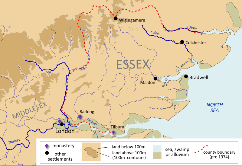
English: A map of Anglo-Saxon Essex and Middlesex, made using File:River Thames and surroudings 2-fr.svg and David Hill, An Atlas of Anglo-Saxon England (1981).
|
||
| Date | |||
| Source | Own work | ||
| Author | Hel-hama |

Licensing
I, the copyright holder of this work, hereby publish it under the following license:
This file is licensed under the Creative Commons Attribution-Share Alike 3.0 Unported license.
- You are free:
- to share – to copy, distribute and transmit the work
- to remix – to adapt the work
- Under the following conditions:
- attribution – You must give appropriate credit, provide a link to the license, and indicate if changes were made. You may do so in any reasonable manner, but not in any way that suggests the licensor endorses you or your use.
- share alike – If you remix, transform, or build upon the material, you must distribute your contributions under the same or compatible license as the original.
File history
Click on a date/time to view the file as it appeared at that time.
| Date/Time | Dimensions | User | Comment | |
|---|---|---|---|---|
| current | 23:56, 21 July 2012 | 1,420 × 975 (748 KB) | Hel-hama | Swamps/alluvium shading added |
File usage
The following page uses this file: