File:German postcode information.png

Size of this preview: 445 × 600 pixels. Other resolutions: 178 × 240 pixels | 356 × 480 pixels | 902 × 1,216 pixels.
Original file (902 × 1,216 pixels, file size: 80 KB, MIME type: image/png)
| This is a file from the Wikimedia Commons. The description on its description page there is shown below.
|
Summary
| Description |
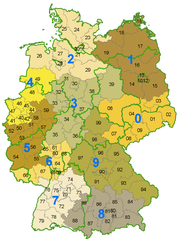
Deutsch: Karte der Postleitzahlen mit Zonen der ersten 2 Ziffern der PLZ und den Bundeslandgrenzen |
| Date | |
| Source | Own work |
| Author | Stefan Kühn |

|
This locator map image could be re-created using vector graphics as an SVG file. This has several advantages; see Commons:Media for cleanup for more information. If an SVG form of this image is available, please upload it and afterwards replace this template with
{{vector version available|new image name}}.
It is recommended to name the SVG file “German postcode information.svg”—then the template Vector version available (or Vva) does not need the new image name parameter. |
Licensing
| This file is made available under the Creative Commons CC0 1.0 Universal Public Domain Dedication. | |
| The person who associated a work with this deed has dedicated the work to the public domain by waiving all of their rights to the work worldwide under copyright law, including all related and neighboring rights, to the extent allowed by law. You can copy, modify, distribute and perform the work, even for commercial purposes, all without asking permission.
|
File history
Click on a date/time to view the file as it appeared at that time.
| Date/Time | Dimensions | User | Comment | |
|---|---|---|---|---|
| current | 03:42, 12 January 2006 | 902 × 1,216 (80 KB) | Eldred | *Beschreibung: **Karte der Postleitzahlen mit Zonen der ersten 2 Ziffern der PLZ und den Bundeslandgrenzen *Quelle: **Erstellt am 18. Juni 2003 *Fotograf oder Zeichner: **Stefan Kühn *Copyright Status: {{GFDL}} |
File usage
The following page uses this file: