File:Greater Macedonia.png
No higher resolution available.
Greater_Macedonia.png (400 × 338 pixels, file size: 11 KB, MIME type: image/png)
| This is a file from the Wikimedia Commons. The description on its description page there is shown below.
|
Summary
| Description |
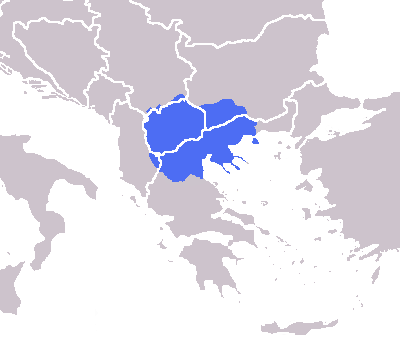
English: The modern greater Macedonian region imposed over national borders. |
| Date | |
| Source | media:Europe blank map.png |
| Author |
|
Licensing
| I, the copyright holder of this work, release this work into the public domain. This applies worldwide. In some countries this may not be legally possible; if so: I grant anyone the right to use this work for any purpose, without any conditions, unless such conditions are required by law. |
File history
Click on a date/time to view the file as it appeared at that time.
| Date/Time | Dimensions | User | Comment | |
|---|---|---|---|---|
| current | 12:08, 14 February 2019 | 400 × 338 (11 KB) | Ασμοδαίος | Reverted to version as of 16:05, 15 February 2014 (UTC) -- the Šar mountains are the modern region's boundary to the north |
File usage
The following page uses this file: