File:Ivan 2004-09-13 1555Z.jpg

Size of this preview: 461 × 599 pixels. Other resolutions: 184 × 240 pixels | 369 × 480 pixels | 461 × 600 pixels | 591 × 768 pixels | 788 × 1,024 pixels | 6,000 × 7,800 pixels.
Original file (6,000 × 7,800 pixels, file size: 6.43 MB, MIME type: image/jpeg)
| This is a file from the Wikimedia Commons. The description on its description page there is shown below.
|
Summary
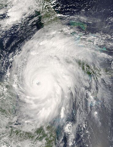
| Description | Now a powerful and rare Category 5 storm, Hurricane Ivan is moving between Cuba, right, and the Yucatan Peninsula, left into the Gulf of Mexico. When the Moderate Resolution Imaging Spectroradiometer (MODIS) on NASA’s Terra satellite acquired this image at 15:55 UTC (10:55 a.m. EDT) on September 13, 2004, the storm boasted winds of 260 kilometers per hour (160 mph). The storm was located about 110 kilometers southeast of Cuba, and was moving northwest at 13 kilometers per hour (8 mph). For more information about Ivan, please visit the National Hurricane Center. | |||||
| Date | ||||||
| Source | http://visibleearth.nasa.gov/view_rec.php?id=6640 | |||||
| Author | Jacques Descloitres, MODIS Rapid Response Team, NASA/GSFC | |||||
| Permission (Reusing this file) |
|

File history
Click on a date/time to view the file as it appeared at that time.
| Date/Time | Dimensions | User | Comment | |
|---|---|---|---|---|
| current | 07:55, 23 September 2006 | 6,000 × 7,800 (6.43 MB) | Good kitty | == Summary == {{Information |Description=Now a powerful and rare Category 5 storm, Hurricane Ivan is moving between Cuba, right, and the Yucatan Peninsula, left into the Gulf of Mexico. When the Moderate Resolution Imaging Spectroradiometer (MODIS) on NAS |
File usage
There are no pages that use this file.