File:Hurricane daniel 2006.jpg

Original file (5,600 × 7,200 pixels, file size: 6.81 MB, MIME type: image/jpeg)
| This is a file from the Wikimedia Commons. The description on its description page there is shown below.
|
Summary
| Description |
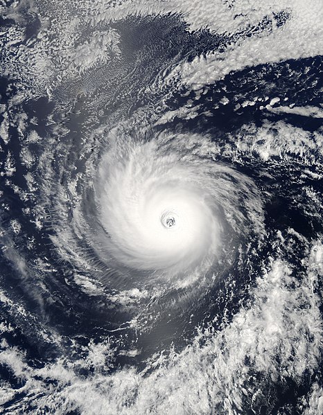
With winds near 240 kilometers per hour (150 miles per hour or 130 knots), Hurricane Daniel was a powerful and dangerous storm when the Moderate Resolution Imaging Spectroradiometer (MODIS) on NASA’s Aqua satellite captured this image on July 21, 2006, over the Eastern Pacific Ocean. Daniel has tightly spiraling clouds that circle an open eye with near-perfect symmetry: hallmarks of a well-organized storm. At the time, 2:55 p.m. Pacific Daylight Time (21:55 UTC), Daniel was a strong Category 4 storm, its winds just a few knots short of a Category 5 storm. The Central Pacific Hurricane Center predicted that the storm would move slowly northwest, gradually degrading into a tropical storm before hitting the island of Hawaii on July 28. The large image provided above has a resolution of 250 meters per pixel. |
|||||
| Date | ||||||
| Source | http://rapidfire.sci.gsfc.nasa.gov/gallery/?2006202-0721/Daniel.A2006202.2155 | |||||
| Author | NASA image courtesy Jeff Schmaltz, MODIS Land Rapid Response Team at NASA GSFC | |||||
| Permission (Reusing this file) |
|

File history
Click on a date/time to view the file as it appeared at that time.
| Date/Time | Dimensions | User | Comment | |
|---|---|---|---|---|
| current | 22:29, 13 July 2019 | 5,600 × 7,200 (6.81 MB) | Nino Marakot | Gallery version, please separate it |
File usage
The following 2 pages use this file: