File:ITH - FAA airport diagram.png

Size of this preview: 390 × 599 pixels. Other resolutions: 156 × 240 pixels | 312 × 480 pixels | 390 × 600 pixels | 805 × 1,237 pixels.
Original file (805 × 1,237 pixels, file size: 36 KB, MIME type: image/png)
| This is a file from the Wikimedia Commons. The description on its description page there is shown below.
|
Summary
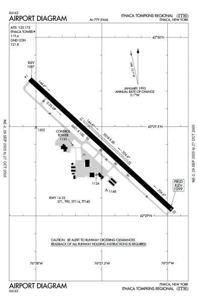
| Description | FAA airport diagram for Ithaca Tompkins Regional Airport (ITH) in Ithaca, New York, United States. |
| Date | Effective 2005-09-29 to 2005-10-27. |
| Source |
http://www.naco.faa.gov/d-tpp/0510/00779AD.PDF Note: this URL changes every 28 days; the airport article should contain a link to the current FAA diagram. |
| Author | Produced by the National Aeronautical Charting Office (NACO), a department of the Federal Aviation Administration (FAA). |
| Permission (Reusing this file) |
Public domain. |
Licensing
This image or file is a work of a Federal Aviation Administration employee, taken or made as part of that person's official duties. As a work of the U.S. federal government, the image is in the public domain in the United States.
|
 |
Original upload log
Originally from en:wikipedia; description page is/was here. (All user names refer to en.wikipedia)
- 2005-10-22 13:54 Zyxw 805×1237×8 (53077 bytes) FAA diagram of [[Ithaca Tompkins Regional Airport]] (ITH) http://www.naco.faa.gov/d-tpp/0510/00779AD.PDF
Original upload log
| date/time | username | resolution | size | edit summary |
|---|---|---|---|---|
| 05:50, 30 September 2007 | User:Darkwind | 805×1,237 | 52 KB | <span class="comment">({{Information |Description=FAA diagram of <a href="http://en.wikipedia.org/wiki/Ithaca_Tompkins_Regional_Airport" class="extiw" title="en:Ithaca_Tompkins_Regional_Airport">en:Ithaca Tompkins Regional Airport</a> (ITH) http://www.naco.faa.gov/d-tpp/0510/00779AD.PDF <a href="http://en.wikipedia.org/wiki/commons:category:Ithaca_Tompkins_Regional_Airport" class="extiw" title="en:commons:category:Ithaca_Tompkins_Regional_Airport">en:commons:category:Ithaca Tompkins Regional Airport</a> [[:en:commons:category:Federal Aviation Administration])</span> |
Original upload log
| Date/Time | Dimensions | User | Comment |
|---|---|---|---|
| 8 May 2008, 17:01:28 | 805 × 1237 (53077 bytes) | BetacommandBot (talk · contribs) | move approved by: [[User:Siebrand]] This image was moved from [[:Image:00779AD.gif]] {{badGIF}} == Summary == {{Information | Description = FAA airport diagram for [[:en:Ithaca Tompkins Regional Airport|Ithaca Tompkins Regional Airport]] (ITH) in Ithac |
File history
Click on a date/time to view the file as it appeared at that time.
| Date/Time | Dimensions | User | Comment | |
|---|---|---|---|---|
| current | 01:06, 18 August 2015 | 805 × 1,237 (36 KB) | GifTagger | Bot: Converting file to superior PNG file. (Source: ITH - FAA airport diagram.gif). This GIF was problematic due to non-greyscale color table. |
File usage
The following page uses this file: