File:Map of USA IL.svg

Size of this PNG preview of this SVG file: 286 × 186 pixels. Other resolutions: 320 × 208 pixels | 640 × 416 pixels | 800 × 520 pixels | 1,024 × 666 pixels | 1,280 × 832 pixels.
Original file (SVG file, nominally 286 × 186 pixels, file size: 167 KB)
| This is a file from the Wikimedia Commons. The description on its description page there is shown below.
|
Clickable version
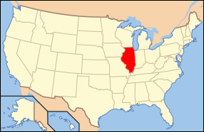
| Description | Map of USA with Illinois highlighted | ||||||||
| Date | see file history below. | ||||||||
| Source | own work by uploader, based on Image:Map of USA without state names.svg | ||||||||
| Author |
This version: uploader Base versions this one is derived from: originally created by en:User:Wapcaplet |
||||||||
| Permission (Reusing this file) |
This file is licensed under the Creative Commons Attribution 2.0 Generic license.
|
||||||||
| Other versions |
Derivative works of this file: Flag map of Illinois.svg image:Map of USA with state names.svg |

File history
Click on a date/time to view the file as it appeared at that time.
| Date/Time | Dimensions | User | Comment | |
|---|---|---|---|---|
| current | 23:29, 8 June 2006 | 286 × 186 (167 KB) | Huebi~commonswiki | {{Information| |Description=Map of USA with Illinois highlighted |other_versions=image:Map of USA with state names.svg }} Category:Maps of the United States Category:Maps of Illinois Category:SVG maps {{GFDL-en}}{{cc-by-2.0}}{{cc-by-sa- |
File usage
The following 16 pages use this file:
- Calhoun County, Illinois
- Clay County, Illinois
- Cook County, Illinois
- Edwards County, Illinois
- Fayette County, Illinois
- Hancock County, Illinois
- Jefferson County, Illinois
- Jo Daviess County, Illinois
- Knox County, Illinois
- Lake County, Illinois
- McLean County, Illinois
- Menard County, Illinois
- St. Clair County, Illinois
- Whiteside County, Illinois
- Will County, Illinois
- Winnebago County, Illinois