File:Map of states showing population density in 2013.svg

Size of this PNG preview of this SVG file: 800 × 495 pixels. Other resolutions: 320 × 198 pixels | 640 × 396 pixels | 1,024 × 633 pixels | 1,280 × 791 pixels | 959 × 593 pixels.
Original file (SVG file, nominally 959 × 593 pixels, file size: 50 KB)
| This is a file from the Wikimedia Commons. The description on its description page there is shown below.
|
Summary
| Description |
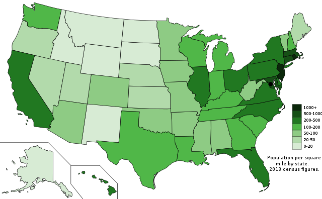
English: The US states with population density shown by people per square mile from the 2013 census, based on data from USCB. |
| Date | |
| Source | Own work; Map is based on here. |
| Author | Ali Zifan |
Licensing
I, the copyright holder of this work, hereby publish it under the following license:
| This file is made available under the Creative Commons CC0 1.0 Universal Public Domain Dedication. | |
| The person who associated a work with this deed has dedicated the work to the public domain by waiving all of their rights to the work worldwide under copyright law, including all related and neighboring rights, to the extent allowed by law. You can copy, modify, distribute and perform the work, even for commercial purposes, all without asking permission.
|
File history
Click on a date/time to view the file as it appeared at that time.
| Date/Time | Dimensions | User | Comment | |
|---|---|---|---|---|
| current | 14:21, 27 November 2014 | 959 × 593 (50 KB) | Oganesson007 | عوض کردن جای توضیحات |
File usage
There are no pages that use this file.