File:Martinsloch.jpg

Size of this preview: 800 × 600 pixels. Other resolutions: 320 × 240 pixels | 640 × 480 pixels | 1,024 × 768 pixels.
Original file (1,024 × 768 pixels, file size: 272 KB, MIME type: image/jpeg)
| This is a file from the Wikimedia Commons. The description on its description page there is shown below.
|
Summary
| Description |
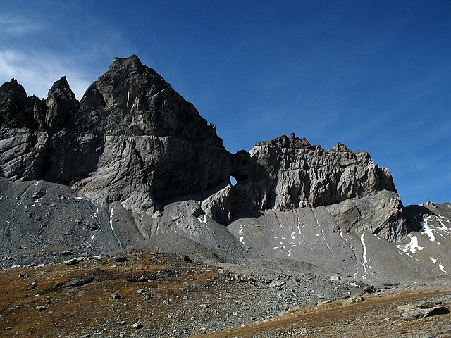
English: Martinsloch (“Martin’s hole”) enclosed by greyish limestone which is overlain by dark grey peak-forming conglomerate (so-called Verrucano) at the Tschingelhörner (ridge between Piz Segnas and Piz Grisch, Glarus Alps, eastern Switzerland; viewing direction is to the west). The Verrucano (Permian) is geologically older than the limestone (Upper Jurassic) and has been thrusted onto it. The well visible line dividing the two rock units is known as the Glarus Main Thrust. |
| Date | |
| Source | Own work |
| Author | Sunna |
| Object location | | View this and other nearby images on: OpenStreetMap |
|---|
Licensing
I, the copyright holder of this work, hereby publish it under the following licenses:
This file is licensed under the Creative Commons Attribution-Share Alike 3.0 Unported license.
- You are free:
- to share – to copy, distribute and transmit the work
- to remix – to adapt the work
- Under the following conditions:
- attribution – You must give appropriate credit, provide a link to the license, and indicate if changes were made. You may do so in any reasonable manner, but not in any way that suggests the licensor endorses you or your use.
- share alike – If you remix, transform, or build upon the material, you must distribute your contributions under the same or compatible license as the original.

|
Permission is granted to copy, distribute and/or modify this document under the terms of the GNU Free Documentation License, Version 1.2 or any later version published by the Free Software Foundation; with no Invariant Sections, no Front-Cover Texts, and no Back-Cover Texts. A copy of the license is included in the section entitled GNU Free Documentation License. |
You may select the license of your choice.
File history
Click on a date/time to view the file as it appeared at that time.
| Date/Time | Dimensions | User | Comment | |
|---|---|---|---|---|
| current | 14:58, 12 December 2008 | 1,024 × 768 (272 KB) | Sunna | {{Information |Description={{en|1=Martinsloch, Tschingelhörner (Glarus Alps)}} |Source=Own work by uploader |Author=Sunna |Date=10.08.08 |Permission= |other_versions= }} <!--{{ImageUpload|full}}--> Category:Canton of Glarus |
File usage
The following 2 pages use this file: