File:North Indian cyclone tracks 1970-2005.jpg

Size of this preview: 800 × 454 pixels. Other resolutions: 320 × 182 pixels | 640 × 363 pixels | 1,024 × 581 pixels | 1,280 × 727 pixels | 2,943 × 1,671 pixels.
Original file (2,943 × 1,671 pixels, file size: 1.19 MB, MIME type: image/jpeg)
| This is a file from the Wikimedia Commons. The description on its description page there is shown below.
|
Summary
| Saffir-Simpson Hurricane Scale | ||||||
| TD | TS | 1 | 2 | 3 | 4 | 5 |
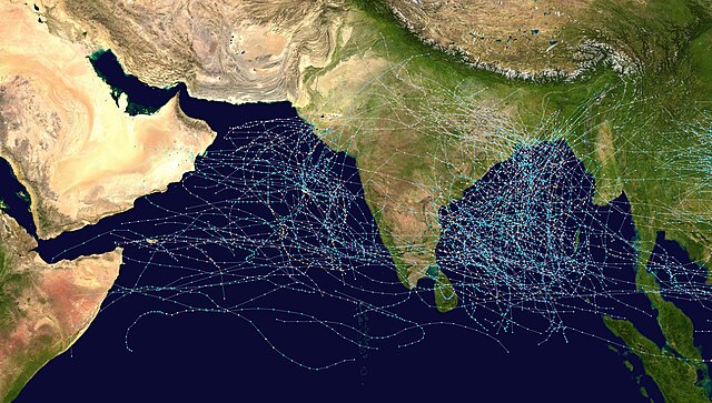
This map shows the tracks of all Tropical cyclones which formed in the north Indian Ocean, or moved into that basin from the northwest Pacific Ocean, from 1970 to 2005. The points show the locations of the storms at six-hourly intervals and use the color scheme shown to the right from Saffir-Simpson Hurricane Scale. Gray points denote unknown strength storms.
Licensing
Created using User:jdorje/Tracks by Nilfanion on 2006-08-16. Background image from Image:Whole_world_-_land_and_oceans.jpg (NASA).
Tracking data for storms is from the Joint Typhoon Warning Center.[1]
| I, the copyright holder of this work, release this work into the public domain. This applies worldwide. In some countries this may not be legally possible; if so: I grant anyone the right to use this work for any purpose, without any conditions, unless such conditions are required by law. |
File history
Click on a date/time to view the file as it appeared at that time.
| Date/Time | Dimensions | User | Comment | |
|---|---|---|---|---|
| current | 08:08, 16 August 2006 | 2,943 × 1,671 (1.19 MB) | Nilfanion | == Summary == {|align="{{{align|right}}}" border="0" cellspacing="0" cellpadding="0" style="background:transparent;text-align:center" |- |colspan="7" nowrap="nowrap"| <small>Saffir-Simpson Hurricane Scale</small> |- |s |
File usage
The following page uses this file: