File:Pays Gallo.svg

Size of this PNG preview of this SVG file: 800 × 564 pixels. Other resolutions: 320 × 225 pixels | 640 × 451 pixels | 1,024 × 721 pixels | 1,280 × 902 pixels | 1,029 × 725 pixels.
Original file (SVG file, nominally 1,029 × 725 pixels, file size: 519 KB)
| This is a file from the Wikimedia Commons. The description on its description page there is shown below.
|
Summary
| Description |
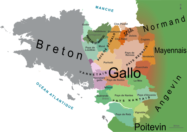
English: Map of the Gallo speaking area in Brittany, France, with the traditional counties and neighbouring languages. Français : Carte du pays gallo en Bretagne, avec les pays traditionnels et les langues voisines. |
| Date | |
| Source | Derivative works of this file: France Pays bretons map.svg, by : Pethrus |
| Author | Oie blanche |
I, the copyright holder of this work, hereby publish it under the following licenses:
This file is licensed under the Creative Commons Attribution-Share Alike 3.0 Unported, 2.5 Generic, 2.0 Generic and 1.0 Generic license.
- You are free:
- to share – to copy, distribute and transmit the work
- to remix – to adapt the work
- Under the following conditions:
- attribution – You must give appropriate credit, provide a link to the license, and indicate if changes were made. You may do so in any reasonable manner, but not in any way that suggests the licensor endorses you or your use.
- share alike – If you remix, transform, or build upon the material, you must distribute your contributions under the same or compatible license as the original.

|
Permission is granted to copy, distribute and/or modify this document under the terms of the GNU Free Documentation License, Version 1.2 or any later version published by the Free Software Foundation; with no Invariant Sections, no Front-Cover Texts, and no Back-Cover Texts. A copy of the license is included in the section entitled GNU Free Documentation License. |
You may select the license of your choice.
Original upload log
This image is a derivative work of the following images:
- File:France_Pays_bretons_map.jpg licensed with Cc-by-sa-3.0,2.5,2.0,1.0, GFDL
- 2010-03-31T12:59:09Z Pethrus 1500x1189 (835023 Bytes) {{Information |Description={{en|Map of the traditionnal regions of Bretagne (France)}}{{fr|Carte des pays traditionnels bretons}} |Source=[http://www.geobreizh.com www.geobreizh.com], Mikael Bodlore-Penlaez |Date=2010-03-30 |
- File:France Pays bretons map.svg licensed with Cc-by-sa-3.0,2.5,2.0,1.0, GFDL
File history
Click on a date/time to view the file as it appeared at that time.
| Date/Time | Dimensions | User | Comment | |
|---|---|---|---|---|
| current | 02:28, 24 May 2013 | 1,029 × 725 (519 KB) | Oie blanche | Text. |
File usage
The following page uses this file: