File:Phoenix Urban Villages.svg

Size of this PNG preview of this SVG file: 299 × 599 pixels. Other resolutions: 120 × 240 pixels | 240 × 480 pixels | 299 × 600 pixels | 383 × 768 pixels | 511 × 1,024 pixels | 502 × 1,005 pixels.
Original file (SVG file, nominally 502 × 1,005 pixels, file size: 34 KB)
| This is a file from the Wikimedia Commons. The description on its description page there is shown below.
|
Summary
| Description |
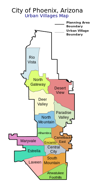
Map of the 15 Urban Villages of Phoenix — within the City of Phoenix, in Maricopa County, Arizona.
|
| Date | |
| Source | My own work, based on government information. Though I strove to be as accurate in the detail as possible, the information isn't one hundred percent accurate. |
| Author | Ixnayonthetimmay |
| Permission (Reusing this file) |
Public Domain |
| Other versions | See Category:Maps of the Urban Villages of Phoenix, Arizona for other versions of this image. |
Licensing
| I, the copyright holder of this work, release this work into the public domain. This applies worldwide. In some countries this may not be legally possible; if so: I grant anyone the right to use this work for any purpose, without any conditions, unless such conditions are required by law. |
File history
Click on a date/time to view the file as it appeared at that time.
| Date/Time | Dimensions | User | Comment | |
|---|---|---|---|---|
| current | 20:51, 7 October 2014 | 502 × 1,005 (34 KB) | Wereldburger758 | Fix error. |
File usage
The following page uses this file: