File:RossIslandMap.jpg

Size of this preview: 750 × 600 pixels. Other resolutions: 300 × 240 pixels | 600 × 480 pixels | 1,000 × 800 pixels.
Original file (1,000 × 800 pixels, file size: 166 KB, MIME type: image/jpeg)
| This is a file from the Wikimedia Commons. The description on its description page there is shown below.
|

|
This file has been superseded by Ross Island Map USGS 250k.png. It is recommended to use the other file. Please note that deleting superseded images requires consent.
|

|
Summary
| Description |
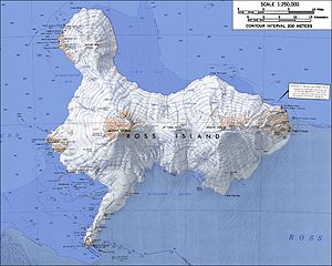
English: Topographic map of Ross Island, Antarctica (1:250,000 scale) Français : Carte topographique de l'île de Ross, Antarctique (échelle 1:250 000) Türkçe: Ross Adası'nın topografik haritası, Antarktika (Ölçek 1:250 000) |
| Date | not specified |
| Source | USGS Atlas of Antarctic Research |
| Author | USGS |
| Other versions |
|


|
|
This file has been superseded by Ross Island Map USGS 250k.png. It is recommended to use the other file. Please note that deleting superseded images requires consent. Reason to use the other file: "higher resolution and rendered in PNG"
|
|
Licensing
This image is in the public domain in the United States because it only contains materials that originally came from the United States Geological Survey, an agency of the United States Department of the Interior. For more information, see the official USGS copyright policy.
|
File history
Click on a date/time to view the file as it appeared at that time.
| Date/Time | Dimensions | User | Comment | |
|---|---|---|---|---|
| current | 17:30, 14 January 2005 | 1,000 × 800 (166 KB) | GarciaB~commonswiki | Topographic map of Ross Island (1:250,000 scale) |
File usage
There are no pages that use this file.