File:South Carolina counties map.png

Size of this preview: 733 × 600 pixels. Other resolutions: 293 × 240 pixels | 587 × 480 pixels | 865 × 708 pixels.
Original file (865 × 708 pixels, file size: 41 KB, MIME type: image/png)
| This is a file from the Wikimedia Commons. The description on its description page there is shown below.
|
Transwiki approved by: w:en:User:Dmcdevit
This image was copied from wikipedia:en. The original description was:
This image or file is a work of a United States Census Bureau employee, taken or made as part of that person's official duties. As a work of the U.S. federal government, the image is in the public domain.
|
 |
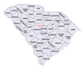
w:en:Category:South Carolina maps
Original upload log
| date/time | username | resolution | size | edit summary |
|---|---|---|---|---|
| 22:58, 24 June 2005 | w:en:User:Jengod | 865×708 | 109 KB | {{PD-USGov-DOC-Census}}<a href="/wiki/Category:South_Carolina_maps" title="Category:South Carolina maps">Category:South Carolina maps</a> |
Image description page history
| link | date/time | username | edit summary |
|---|---|---|---|
| http://en.wikipedia.org/w/index.php?title=Image:South_Carolina_counties_map.png&redirect=no&oldid=17718416 | 08:08, 16 September 2007 | w:en:User:Dmcdevit | |
| http://en.wikipedia.org/w/index.php?title=Image:South_Carolina_counties_map.png&redirect=no&oldid=17718416 | 22:58, 24 June 2005 | w:en:User:Jengod | ({{PD-USGov-DOC-Census}}<a href="/wiki/Category:South_Carolina_maps" title="Category:South Carolina maps">Category:South Carolina maps</a>) |
derivative works
Derivative works of this file: SCjudicialcircuits.png
File history
Click on a date/time to view the file as it appeared at that time.
| Date/Time | Dimensions | User | Comment | |
|---|---|---|---|---|
| current | 12:49, 16 July 2015 | 865 × 708 (41 KB) | Cmdrjameson | Compressed with pngout. Reduced by 67kB (62% decrease). |
File usage
The following page uses this file: