File:Summitting Island Peak.jpg

Size of this preview: 450 × 600 pixels. Other resolutions: 180 × 240 pixels | 360 × 480 pixels | 576 × 768 pixels | 768 × 1,024 pixels | 1,536 × 2,048 pixels.
Original file (1,536 × 2,048 pixels, file size: 3.12 MB, MIME type: image/jpeg)
| This is a file from the Wikimedia Commons. The description on its description page there is shown below.
|
Summary
| Description |
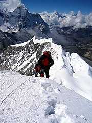
English: Climber taking the final few steps onto the 20,305 ft. (6,189 m) summit of Imja Tse (Island Peak) in Nepal.
Español: Alpinista tomando los pasos finales a pocos pies de la cima del Imja Tse (Island Peak) a 20.305 pies (6.189 m) en Nepal.
Français : Alpiniste finissant l'ascension de l'Imja Tse (ou Island Peak) (6 189 m), au Népal.
|
| Date | |
| Source | Own work |
| Author | Mountaineer |
| Camera location | | View this and other nearby images on: OpenStreetMap |
|---|
|

This image was selected as picture of the day on Wikimedia Commons for 10 May 2009. It was captioned as follows: English: Climber taking the final few steps onto the 20,305 ft. (6,189 m) summit of Imja Tse (Island Peak) in Nepal. Other languages:
Afrikaans: Finale treë na die (20,305vt; 6,189m) bergtop van Imja Tse (Eilandpiek) in Nepal Bosanski: Planinari prave zadnje korake do sastanka na 6,189 m na Imja Tse-u (vrh na Himalaji) u Nepalu. Dansk: En bjergbestiger når toppen af det 6.189 m høje Imja Tse (Island Peak) i den nepalesiske del af Himalaya. Deutsch: Bergsteiger erreichen den Gipfel des 6189 m hohen Imja Tse im nepalesischen Teil des Himalayas English: Climber taking the final few steps onto the 20,305 ft. (6,189 m) summit of Imja Tse (Island Peak) in Nepal. Español: Escalador dando los últimos pasos en la cima a 6189 m del Imja Tse en Nepal. Français : Alpiniste finissant l'ascension de l'Imja Tse (ou Island Peak) (6 189 m), au Népal. Polski: Himalaista tuż przed zdobyciem szczytu Imja Tse (6 189 m) w Nepalu. Română: Alpinist aproape de finalul urcării pe vârful Imja Tse (Vârful Insulei, 6.189 m) din Nepal. Suomi: Kiipeilijä nousemassa 6 189 metriä korkean Imja Tsen huipulle Nepalissa. Македонски: Планинар ги прави последните чекори (6.189 m) на врвот Имџа Це („Островски Врв“) во Непал. Русский: Альпинист завершает подъём на вершину Имджацзе (6189 метров) в Непале 한국어: 등산가가 네팔 임자체 (아일랜드 피크)의 정상 20,305 피트 (6,198 미터)까지 몇 걸음만을 남기고 있다. 中文: 登山者即将登顶尼泊尔喜马拉雅山脉海拔6189米的伊姆扎谢(岛峰) |
Licensing
I, the copyright holder of this work, hereby publish it under the following license:
This file is licensed under the Creative Commons Attribution 3.0 Unported license.
- You are free:
- to share – to copy, distribute and transmit the work
- to remix – to adapt the work
- Under the following conditions:
- attribution – You must give appropriate credit, provide a link to the license, and indicate if changes were made. You may do so in any reasonable manner, but not in any way that suggests the licensor endorses you or your use.
| Annotations | This image is annotated: View the annotations at Commons |
File history
Click on a date/time to view the file as it appeared at that time.
| Date/Time | Dimensions | User | Comment | |
|---|---|---|---|---|
| current | 08:31, 17 January 2009 | 1,536 × 2,048 (3.12 MB) | Mountaineer | {{Information |Description= |Source= |Date= |Author= |Permission= |other_versions= }} |
File usage
The following page uses this file: