File:Topographic map of Greenland bedrock.jpg

Size of this preview: 461 × 599 pixels. Other resolutions: 185 × 240 pixels | 369 × 480 pixels | 462 × 600 pixels | 802 × 1,042 pixels.
Original file (802 × 1,042 pixels, file size: 267 KB, MIME type: image/jpeg)
| This is a file from the Wikimedia Commons. The description on its description page there is shown below.
|
Summary
| Description |
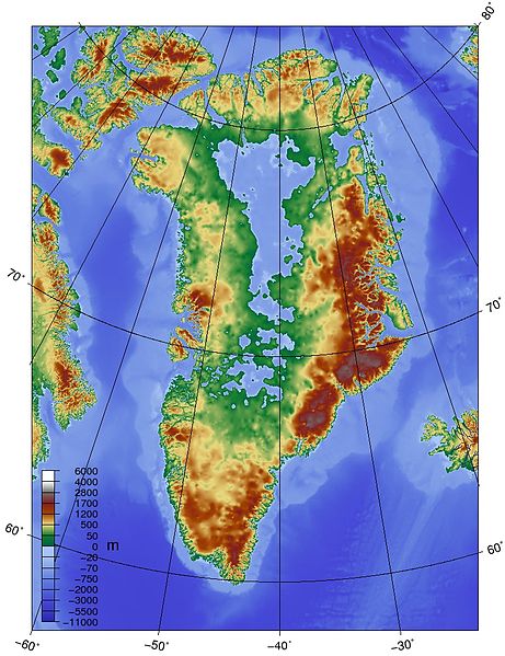
English: Topographic map of Greenland bedrock, in effect showing the topography without the extant ice sheet. Created using ETOPO1 Global Relief Model bedrock version from [1]. |
| Source | Own work |
| Author | Skew-t |

|
This map image could be re-created using vector graphics as an SVG file. This has several advantages; see Commons:Media for cleanup for more information. If an SVG form of this image is available, please upload it and afterwards replace this template with
{{vector version available|new image name}}.
It is recommended to name the SVG file “Topographic map of Greenland bedrock.svg”—then the template Vector version available (or Vva) does not need the new image name parameter. |


Licensing
I, the copyright holder of this work, hereby publish it under the following license:
This file is licensed under the Creative Commons Attribution-Share Alike 3.0 Unported license.
- You are free:
- to share – to copy, distribute and transmit the work
- to remix – to adapt the work
- Under the following conditions:
- attribution – You must give appropriate credit, provide a link to the license, and indicate if changes were made. You may do so in any reasonable manner, but not in any way that suggests the licensor endorses you or your use.
- share alike – If you remix, transform, or build upon the material, you must distribute your contributions under the same or compatible license as the original.
File history
Click on a date/time to view the file as it appeared at that time.
| Date/Time | Dimensions | User | Comment | |
|---|---|---|---|---|
| current | 09:19, 25 May 2010 | 802 × 1,042 (267 KB) | Skew-t | {{Information |Description={{en|1=Topographic map of Greenland bedrock, in effect showing the topography without the extant ice sheet. Created using ETOPO1 Global Relief Model bedrock version from [http://www.ngdc.noaa.gov/mgg/global/global.html].}} |Sour |
File usage
The following page uses this file: