File:Verbreitungsgebiet der heutigen niederdeutschen Mundarten.svg

Size of this PNG preview of this SVG file: 555 × 599 pixels. Other resolutions: 222 × 240 pixels | 444 × 480 pixels | 556 × 600 pixels | 711 × 768 pixels | 948 × 1,024 pixels | 789 × 852 pixels.
Original file (SVG file, nominally 789 × 852 pixels, file size: 289 KB)
| This is a file from the Wikimedia Commons. The description on its description page there is shown below.
|
Summary
| Description |
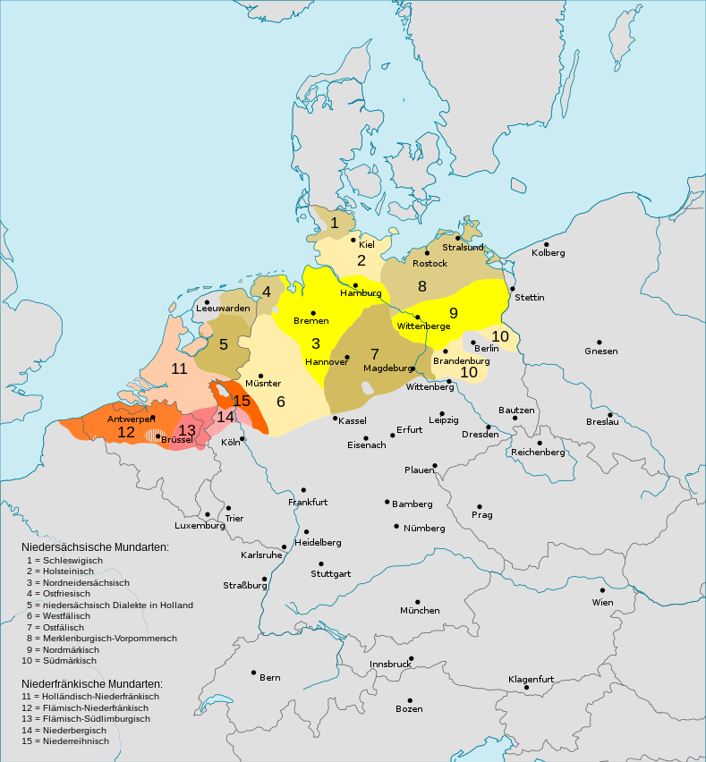
Deutsch: Darstellungskarte der niederdeutschen Mundarten seit 1945
English: Distribution map of the Low Saxon and Low Franconian languages since 1945. Note however that it's bad: "Niedersächsische Mundarten [Low Saxon dialects]: ... 4 = Ostfriesisch [East Frisian] 5 Niedersächsische Dialekte in den Niederlanden [Low Saxon dialects in the Netherlands]" – Parts of what's labelled East Frisian are in the North-East of the Netherlands. Und auch: “niederrheinisch” statt “niederreihnisch” (n°15). |
| Date | (UTC) |
| Source | |
| Author |
|
| Other versions |
Englisch / English:  |


Licensing
I, the copyright holder of this work, hereby publish it under the following license:
This file is licensed under the Creative Commons Attribution-Share Alike 3.0 Unported license.
- You are free:
- to share – to copy, distribute and transmit the work
- to remix – to adapt the work
- Under the following conditions:
- attribution – You must give appropriate credit, provide a link to the license, and indicate if changes were made. You may do so in any reasonable manner, but not in any way that suggests the licensor endorses you or your use.
- share alike – If you remix, transform, or build upon the material, you must distribute your contributions under the same or compatible license as the original.
Original upload log
This image is a derivative work of the following images:
- File:Verbreitungsgebiet_der_heutigen_niederdeutschen_Mundarten.PNG licensed with PD-user-de, PD-user-w
- 2008-08-08T10:33:32Z Gruna 1 652x652 (37059 Bytes) See previous version
- 2006-04-14T17:48:45Z Vonvon 652x652 (36806 Bytes) * created on de.wikipedia.org by [[:de:Benutzer:Postmann Michael]] on 31 December 2004 * Beschreibung:Darstellungskarte der niederdeutschen Mundarten seit 1945 (''Location Map of the Low Germanic languages'') * original licen
- File:Europe.svg licensed with PD-USGov-CIA-WF
Uploaded with derivativeFX
File history
Click on a date/time to view the file as it appeared at that time.
| Date/Time | Dimensions | User | Comment | |
|---|---|---|---|---|
| current | 11:29, 7 August 2022 | 789 × 852 (289 KB) | Mc zelani | Reverted to version as of 14:40, 7 February 2011 (UTC) |
File usage
There are no pages that use this file.