File:Vesta-Elevation.jpg
No higher resolution available.
Vesta-Elevation.jpg (500 × 500 pixels, file size: 43 KB, MIME type: image/jpeg)
| This is a file from the Wikimedia Commons. The description on its description page there is shown below.
|
| Description |
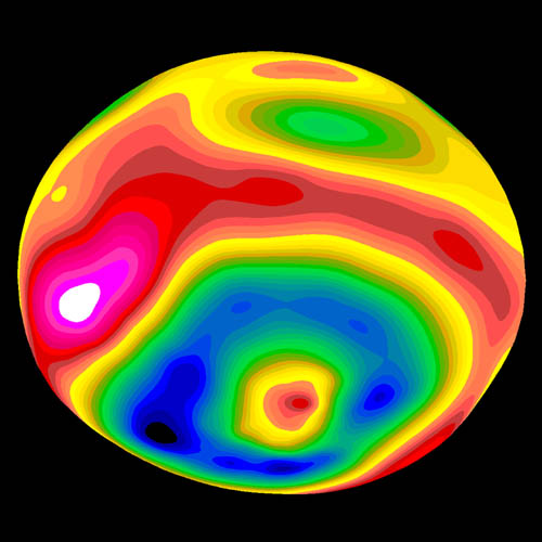
A color-encoded elevation map of Vesta clearly shows the giant 460-kilometer diameter impact basin and "bull's-eye" central peak. The map was constructed from 78 Wide Field Planetary Camera 2 pictures. Surface topography was estimated by noting irregularities along the limb and at the terminator (day/night boundary) where shadows are enhanced by the low Sun angle. Deutsch: Farbkodierte Höhenkarte von Vesta.
Polski: Mapa Westy ukazująca różnice w wysokościach na jej powierzchni |
| Date | Image published 1997 September 4 |
| Source | http://hubblesite.org/newscenter/newsdesk/archive/releases/1997/27/image/e |
| Author | Ben Zellner (Georgia Southern University) and NASA |
| Permission (Reusing this file) |
Unless otherwise specifically stated, no claim to copyright is being asserted by STScI and it may be freely used as in the public domain in accordance with NASA's contract. [...] [1] |
| This file is in the public domain in the United States because it was solely created by NASA. NASA copyright policy states that "NASA material is not protected by copyright unless noted". (See Template:PD-USGov, NASA copyright policy page or JPL Image Use Policy.) | ||
 |
Warnings:
|
File history
Click on a date/time to view the file as it appeared at that time.
| Date/Time | Dimensions | User | Comment | |
|---|---|---|---|---|
| current | 00:57, 30 January 2006 | 500 × 500 (43 KB) | Arnomane | higher resolution |
File usage
The following page uses this file: