File:View from connors hill panorama.jpg

Size of this preview: 800 × 199 pixels. Other resolutions: 320 × 80 pixels | 640 × 159 pixels | 1,024 × 255 pixels | 1,280 × 318 pixels | 4,289 × 1,067 pixels.
Original file (4,289 × 1,067 pixels, file size: 1.14 MB, MIME type: image/jpeg)
| This is a file from the Wikimedia Commons. The description on its description page there is shown below.
|
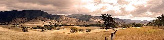
This image was selected as picture of the day on Wikimedia Commons for 15 March 2009. It was captioned as follows: English: View from Connors Hill in East Gippsland Shire, Victoria, Australia. Other languages:
Afrikaans: Uitsig vanaf Connorsheuwel in die Oos-Gippslanddistrik van die Australiese deelstaat Victoria Bosanski: Pogled sa Connors Hill-a u Istočnom Gippsland Shire-u u Viktoriji u Australiji. Dansk: Udsigt fra Connors Hill i East Gippsland Shire, Victoria, Australien. Deutsch: Blick vom Connor-Hügel im lokalen Verwaltungsgebiet East Gippsland Shire im australischen Bundesstaat Victoria English: View from Connors Hill in East Gippsland Shire, Victoria, Australia. Español: Vista desde Connors Hill en East Gippsland Shire, Victoria, Australia. Esperanto: rigardo de la moneteto Connors Hill al pejzaĝo en la adminstra regiono East Gippsland Shire en Viktorio, Aŭstralio. Íslenska: Útsýni frá Connors Hill í East Gippsland Shire, Viktoríufylki, Ástralíu. Magyar: Kilátás a Connors Hillről (Ausztrália, Victora, East Gippsland Shire) Português: Vista a partir de Connors Hill, em East Gippsland Shire, Victoria, Austrália Suomi: Näkymä Connors Hillistä, East Gippsland Shirestä, Victoriasta, Australiasta. Winaray: An lantaw tikang ha Connors Hill ha East Gippsland Shire, Victoria, Australia. 한국어: 오스트레일리아의 빅토리아 주에 있는 에스트 깁슬랜드 샤이어의 코너스 힐. 中文: 澳大利亚东吉普斯兰郡康纳斯山风景 中文(繁體): 澳洲東吉普斯蘭郡康納斯山風景 |
This image was selected as picture of the day on Vietnamese Wikipedia.
|
|

| Description |
Français : Vue de Connors Hill dans le comté du Gippsland oriental, État de Victoria, Australie. |
| Source | Own work |
| Author | User:Fir0002 |
| Camera location | | View this and other nearby images on: OpenStreetMap |
|---|
|


| ||||||||


|
Permission is granted to copy, distribute and/or modify this document under the terms of the GNU Free Documentation License, Version 1.2 only as published by the Free Software Foundation; with no Invariant Sections, no Front-Cover Texts, and no Back-Cover Texts. A copy of the license is included in the section entitled GNU Free Documentation License. | 1.2 only |
This file is published under the following Creative Commons license:
Attribution NonCommercial Unported 3.0 |
File history
Click on a date/time to view the file as it appeared at that time.
| Date/Time | Dimensions | User | Comment | |
|---|---|---|---|---|
| current | 15:22, 28 October 2012 | 4,289 × 1,067 (1.14 MB) | Fir0002 | Reverted to version as of 02:15, 11 January 2006 |