File:Wooden cross on the ridge between Tguma and Präzer Höhi (2).jpg

Size of this preview: 800 × 535 pixels. Other resolutions: 320 × 214 pixels | 640 × 428 pixels | 1,024 × 685 pixels | 1,280 × 856 pixels | 4,878 × 3,262 pixels.
Original file (4,878 × 3,262 pixels, file size: 7.71 MB, MIME type: image/jpeg)
| This is a file from the Wikimedia Commons. The description on its description page there is shown below.
|
Summary
| Description |
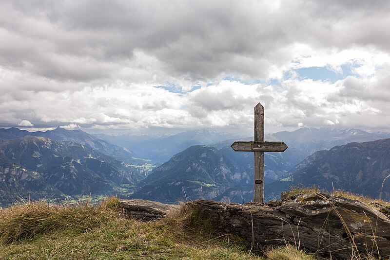
Nederlands: Bergtocht van Sarner Alp (1853 meter) via Präzer Höhi (2119 meter) naar Tguma (2163 meter). Afdalen naar Berggasthaus Parsiras. Uitzicht vanaf de bergkam. Er is veel regen opkomst.
English: Mountain trip from Sarner Alp (1853 meter) via Präzer Höhi (2119 meter) to Tguma (2163 meter). Wooden cross on the ridge between Tguma and Präzer Höhi. There is a lot of rain coming.
Deutsch: Holzkreuz auf dem Grat zwischen Tguma und Präzer Höhi |
| Date | |
| Source | Own work |
| Author | Dominicus Johannes Bergsma |
| Other versions |
|
.jpg)
|

.jpg)
.jpg)
.jpg)
| Camera location | | View this and other nearby images on: OpenStreetMap |
|---|
.jpg¶ms=046.718952_N_0009.355992_E_globe:Earth_type:camera_heading:112.50&language=en)
High mountain Präzer Höhi (2119 meters) to Tguma (2163 meters).
Licensing
I, the copyright holder of this work, hereby publish it under the following license:
This file is licensed under the Creative Commons Attribution-Share Alike 4.0 International license.
- You are free:
- to share – to copy, distribute and transmit the work
- to remix – to adapt the work
- Under the following conditions:
- attribution – You must give appropriate credit, provide a link to the license, and indicate if changes were made. You may do so in any reasonable manner, but not in any way that suggests the licensor endorses you or your use.
- share alike – If you remix, transform, or build upon the material, you must distribute your contributions under the same or compatible license as the original.
This image has been assessed using the Quality image guidelines and is considered a Quality image.
|

|
This image has been assessed under the valued image criteria and is considered the most valued image on Commons within the scope: Präzer Höhi Wooden cross on the ridge between Tguma and Präzer Höhi. West side cross. Looking east.. You can see its nomination here. |
File history
Click on a date/time to view the file as it appeared at that time.
| Date/Time | Dimensions | User | Comment | |
|---|---|---|---|---|
| current | 00:57, 30 October 2017 | 4,878 × 3,262 (7.71 MB) | Famberhorst | User created page with UploadWizard |
File usage
The following page uses this file:
.jpg)