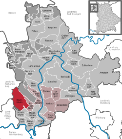
Bischbrunn
Bischbrunn is a community with around 1,800 (2013) residents in Main-Spessart in the Regierungsbezirk of Lower Franconia (Unterfranken) in Bavaria, Germany and a member of the Verwaltungsgemeinschaft (Administrative Community) of Marktheidenfeld.
| Coordinates: 49°52′13″N 09°29′21″E / 49.87028°N 9.48917°ECoordinates: 49°52′13″N 09°29′21″E / 49.87028°N 9.48917°E | |
| Country | Germany |
| State | Bavaria |
| Admin. region | Unterfranken |
| District | Main-Spessart |
| Municipal assoc. | Marktheidenfeld |
| Government | |
| • Mayor (2020–26) | Agnes Engelhardt[1] |
| Area | |
| • Total | 36.18 km2 (13.97 sq mi) |
| Elevation | 395 m (1,296 ft) |
| Population (2016-12-31)[2] | |
| • Total | 1,819 |
| • Density | 50.276/km2 (130.22/sq mi) |
| Time zone | UTC+01:00 (CET) |
| • Summer (DST) | UTC+02:00 (CEST) |
| Postal codes | 97836, 97852 (Schleifmühle) |
| Vehicle registration | MSP |
| Website | www |
Geography
Location
Bischbrunn is in Main-Spessart, in the Würzburg Region. It is in the Spessart range of hills. The Geiersberg, the highest elevation in the Spessart is in the municipal territory.
The community has the following Gemarkungen (traditional rural cadastral areas): Bischbrunn, Bischbrunner Forst, Fürstlich Löwenstein'scher Park, Oberndorf.
References
- ↑ Liste der ersten Bürgermeister/Oberbürgermeister in kreisangehörigen Gemeinden, Bayerisches Landesamt für Statistik, 15 July 2021.
- ↑ "Fortschreibung des Bevölkerungsstandes". Bayerisches Landesamt für Statistik und Datenverarbeitung (in German). January 2018.
{{cite web}}: CS1 maint: unrecognized language (link)
Other websites
| Wikimedia Commons has media related to Lua error in Module:Commons_link at line 62: attempt to index field 'wikibase' (a nil value).. |

