Bischofsheim in der Rhön
Bischofsheim in der Rhön (before January 2020, the town was called: Bischofsheim an der Rhön) is a town in Rhön-Grabfeld, in Bavaria, Germany. It is in the Rhön Mountains, 29 km southeast of Fulda.
 | |
_COA.svg) Coat of arms | |
Location of Bischofsheim i.d.Rhön within Rhön-Grabfeld district  | |
| Coordinates: 50°24′N 10°01′E / 50.400°N 10.017°ECoordinates: 50°24′N 10°01′E / 50.400°N 10.017°E | |
| Country | Germany |
| State | Bavaria |
| Admin. region | Unterfranken |
| District | Rhön-Grabfeld |
| Subdivisions | 5 Stadtteile |
| Government | |
| • Mayor (2016–22) | Georg Seiffert[1] (CSU) |
| Area | |
| • Total | 67.72 km2 (26.15 sq mi) |
| Elevation | 448 m (1,470 ft) |
| Population (2016-12-31)[2] | |
| • Total | 4,707 |
| • Density | 69.507/km2 (180.02/sq mi) |
| Time zone | UTC+01:00 (CET) |
| • Summer (DST) | UTC+02:00 (CEST) |
| Postal codes | 97653 |
| Vehicle registration | NES |
| Website | www.bischofsheim-rhoen.de |
Town Structure
Several originally separate villages became part of the town Bischofsheim. These are Frankenheim, Haselbach, Oberweißenbrunn, Unterweißenbrunn and Wegfurt.
Sights
- Kreuzberg, 2nd highest mountain of the Rhön Mountains (932 metres)
- Kloster Kreuzberg (monastery, built 1681 – 1692)
- Town tower Zehntturm (13th century, 26 metres high)
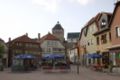
Market place of Bischofsheim

Tower „Zentturm“

Crosses on the Kreuzberg


_9596.jpg)
Bischofsheim In Der Rhön Media

Johann Joseph von Prechtl around 1815

References
- ↑ Liste der ersten Bürgermeister/Oberbürgermeister in kreisangehörigen Gemeinden, Bayerisches Landesamt für Statistik, accessed 19 July 2021.
- ↑ "Fortschreibung des Bevölkerungsstandes". Bayerisches Landesamt für Statistik und Datenverarbeitung (in German). January 2018.
{{cite web}}: CS1 maint: unrecognized language (link)