Cadolzburg
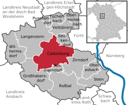
Cadolzburg (outdated also Kadolzburg, colloquially pronounced "Kalschbuʳch" or "Sporch" German pronunciation: [ʃbɔrχ]) is a municipality in the Middle Franconian district of Fürth, in Bavaria, Germany. It is 11 km (6.8 mi) west of Fürth. Its name comes from its central castle, first being mentioned in the year 1157.[3]
 | |
| Coordinates: 49°27′N 10°52′E / 49.450°N 10.867°ECoordinates: 49°27′N 10°52′E / 49.450°N 10.867°E | |
| Country | Germany |
| State | Bavaria |
| Admin. region | Mittelfranken |
| District | Fürth |
| Subdivisions | 16 districts |
| Government | |
| • Mayor (2020–26) | Bernd Obst[1] (CSU) |
| Area | |
| • Total | 45.44 km2 (17.54 sq mi) |
| Elevation | 352 m (1,155 ft) |
| Population (2016-12-31)[2] | |
| • Total | 10,976 |
| • Density | 241.55/km2 (625.61/sq mi) |
| Time zone | UTC+01:00 (CET) |
| • Summer (DST) | UTC+02:00 (CEST) |
| Postal codes | 90556 |
| Vehicle registration | FÜ |
| Website | www.cadolzburg.de |
Geography
The topography varies significantly in its height.
Neighborhood
Neighboring Municipalities are: (beginning in the north then going clockwise)
Districts
Cadolzburg consists of the city itself and 15 farther districts:[4]
|
|
|
Cadolzburg Media
References
- ↑ Liste der ersten Bürgermeister/Oberbürgermeister in kreisangehörigen Gemeinden, Bayerisches Landesamt für Statistik, 15 July 2021.
- ↑ "Fortschreibung des Bevölkerungsstandes". Bayerisches Landesamt für Statistik und Datenverarbeitung (in German). January 2018.
{{cite web}}: CS1 maint: unrecognized language (link) - ↑ Wiessner, W. W.-A. v. Reitzenstein.
- ↑ "Bayerische Landesbibliothek Online (BLO)". bayerische-landesbibliothek-online.de. Retrieved 14 March 2019.


