Châtel-sur-Montsalvens
Châtel-sur-Montsalvens is a municipality of the district of Gruyère in the canton of Fribourg in Switzerland.
 | |
 Coat of arms | |
Location of Châtel-sur-Montsalvens
Lua error in Module:Infobox_mapframe at line 118: attempt to index field 'wikibase' (a nil value).
| |
| Coordinates: 46°37′N 7°8′E / 46.617°N 7.133°ECoordinates: 46°37′N 7°8′E / 46.617°N 7.133°E | |
| Country | Switzerland |
| Canton | Fribourg |
| District | Gruyère |
| Government | |
| • Mayor | Syndic |
| Area | |
| • Total | 2.00 km2 (0.77 sq mi) |
| Elevation | 908 m (2,979 ft) |
| Population (December 2017) | |
| • Total | 285 |
| • Density | 142.5/km2 (369.1/sq mi) |
| Time zone | UTC+01:00 (Central European Time) |
| • Summer (DST) | UTC+02:00 (Central European Summer Time) |
| Postal code(s) | 1653 |
| Surrounded by | Botterens, Broc, Cerniat, Crésuz, Villarbeney |
| Website | www SFSO statistics |
Châtel-sur-Montsalvens Media
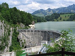
Le barrage de Montsalvens, construit en 1920 à proximité de Charmey, en Suisse, fut le premier barrage de type voûte à courbure horizontale et verticale en Europe.

References
Other websites
![]() Media related to Châtel-sur-Montsalvens at Wikimedia Commons
Media related to Châtel-sur-Montsalvens at Wikimedia Commons