Cole, Oklahoma
Cole is a town in the U.S. state of Oklahoma.
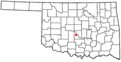
 Location of Cole, Oklahoma | |
| Coordinates: 35°06′21″N 97°33′54″W / 35.10583°N 97.56500°WCoordinates: 35°06′21″N 97°33′54″W / 35.10583°N 97.56500°W | |
| Country | United States |
| State | Oklahoma |
| County | McClain |
| Area | |
| • Total | 15.07 sq mi (39.03 km2) |
| • Land | 14.98 sq mi (38.80 km2) |
| • Water | 0.09 sq mi (0.23 km2) |
| Elevation | 1,112 ft (339 m) |
| Population (2020) | |
| • Total | 624 |
| • Density | 41.65/sq mi (16.08/km2) |
| Time zone | UTC-6 (Central (CST)) |
| • Summer (DST) | UTC-5 (CDT) |
| FIPS code | 40-16200[3] |
| GNIS feature ID | 2413225[2] |
References
- ↑ "ArcGIS REST Services Directory". United States Census Bureau. Retrieved September 20, 2022.
- ↑ 2.0 2.1 U.S. Geological Survey Geographic Names Information System: Cole, Oklahoma
- ↑ "U.S. Census website". United States Census Bureau. Retrieved January 31, 2008.