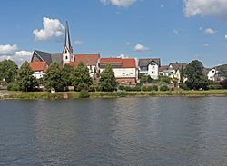
Erlenbach am Main
Erlenbach am Main (officially: Erlenbach a.Main) is the largest town in the Miltenberg district in the Lower Franconia region in Bavaria, Germany. About 10,000 people live in Erlenbach am Main.
 | |
| Coordinates: 49°48′14″N 9°9′50″E / 49.80389°N 9.16389°ECoordinates: 49°48′14″N 9°9′50″E / 49.80389°N 9.16389°E | |
| Country | Germany |
| State | Bavaria |
| Admin. region | Unterfranken |
| District | Miltenberg |
| Subdivisions | 3 Stadtteile |
| Government | |
| • Mayor (2017–23) | Michael Berninger[1] (CSU) |
| Area | |
| • Total | 16.33 km2 (6.31 sq mi) |
| Elevation | 129 m (423 ft) |
| Population (2016-12-31)[2] | |
| • Total | 10,138 |
| • Density | 620.82/km2 (1,607.9/sq mi) |
| Time zone | UTC+01:00 (CET) |
| • Summer (DST) | UTC+02:00 (CEST) |
| Postal codes | 63906 |
| Vehicle registration | MIL |
| Website | www.stadt-erlenbach.de |
Erlenbach is the site of one of the Miltenberg district's two hospitals, and is well known for its wine. Until 25 years ago, Erlenbach was Bavaria's newest town.[source?]
Geography
Place
Erlenbach is in Lower Franconia in Bavaria's northwest, at the Mainviereck (“Main Square”), near Aschaffenburg.
Constituent communities
The formerly self-administering neighbouring communities of Mechenhard and Streit were combined with Erlenbach in 1976 and 1978, respectively.
Erlenbach Am Main Media
References
- ↑ Liste der ersten Bürgermeister/Oberbürgermeister in kreisangehörigen Gemeinden, Bayerisches Landesamt für Statistik, accessed 19 July 2021.
- ↑ "Fortschreibung des Bevölkerungsstandes". Bayerisches Landesamt für Statistik und Datenverarbeitung (in German). January 2018.
{{cite web}}: CS1 maint: unrecognized language (link)
Other websites
| Wikimedia Commons has media related to Lua error in Module:Commons_link at line 62: attempt to index field 'wikibase' (a nil value).. |
- Town’s official webpage (in German)


