File:160322-066 View from Thiri.jpg

Size of this preview: 800 × 450 pixels. Other resolutions: 320 × 180 pixels | 640 × 360 pixels | 1,024 × 576 pixels | 1,280 × 720 pixels | 4,608 × 2,592 pixels.
Original file (4,608 × 2,592 pixels, file size: 9.18 MB, MIME type: image/jpeg)
| This is a file from the Wikimedia Commons. The description on its description page there is shown below.
|
Summary
| Description |
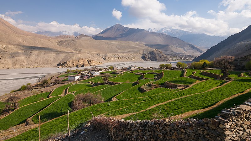
English: A view of the Kali Gandaki valley overlooking the village of Thiri, Nepal.
Español: Vista del valle de Kali Gandaki a la altura del pueblo de Thiri, provincia de Gandaki, Nepal.
|
| Date | Taken on 22 March 2016, 16:08:44 |
| Source | Own work |
| Author | Faj2323 |
| Camera location | | View this and other nearby images on: OpenStreetMap |
|---|
Assessment
|
This image was selected as picture of the day on Wikimedia Commons for 13 April 2024. It was captioned as follows: English: A view of the Kali Gandaki valley overlooking the village of Thiri, Nepal. Today is Bisket Jatra in Nepal. Other languages:
Čeština: Pohled na horské údolí Kali Gandaki Gorge nad vesnicí Thiri v Nepálu. Dnes se v Nepálu koná každoroční slavnost Bisket Jatra. Deutsch: Das Kali-Gandaki-Tal mit dem Dorf Thiri in Nepal. English: A view of the Kali Gandaki valley overlooking the village of Thiri, Nepal. Today is Bisket Jatra in Nepal. Español: Vista del valle del Kali Gandaki a la altura del pueblo de Thiri, provincia de Gandaki, Nepal. Français : La vallée de la Kali Gandaki près du village de Thiri (Népal). Italiano: Vista della valle del fiume Gaṇḍaki nei pressi del villaggio di Thiri, provincia di Gandaki, Nepal. Magyar: A Kali Gandaki-völgy látképe a Thiri település felett (Nepál) Македонски: Поглед на клисурата Кали Гандаки и селото Тири во Непал. Русский: Вид на деревню Тири в долине реки Гандак. В верхнем течении (на илл.) река носит название Кали-Гандак. Берёт начало в Гималаях. Гандаки-Прадеш, Непал Українська: Вид на долину Калі Ґандакі з видом на село Тірі, провінція Ґандакі, Непал. Сьогодні «Біскет Джатра», щорічний фестиваль в Непалі. |
This image was uploaded as part of Wiki Loves Earth 2017.
|
 |
Licensing
I, the copyright holder of this work, hereby publish it under the following license:
This file is licensed under the Creative Commons Attribution-Share Alike 4.0 International license.
- You are free:
- to share – to copy, distribute and transmit the work
- to remix – to adapt the work
- Under the following conditions:
- attribution – You must give appropriate credit, provide a link to the license, and indicate if changes were made. You may do so in any reasonable manner, but not in any way that suggests the licensor endorses you or your use.
- share alike – If you remix, transform, or build upon the material, you must distribute your contributions under the same or compatible license as the original.
File history
Click on a date/time to view the file as it appeared at that time.
| Date/Time | Dimensions | User | Comment | |
|---|---|---|---|---|
| current | 03:32, 28 May 2022 | 4,608 × 2,592 (9.18 MB) | UnpetitproleX | slight sharpening, noise reduction |
File usage
There are no pages that use this file.