File:1863 Strood.jpg
Size of this preview: 562 × 600 pixels. Other resolutions: 225 × 240 pixels | 450 × 480 pixels | 702 × 749 pixels.
Original file (702 × 749 pixels, file size: 113 KB, MIME type: image/jpeg)
| This is a file from the Wikimedia Commons. The description on its description page there is shown below.
|
Summary
| Description |
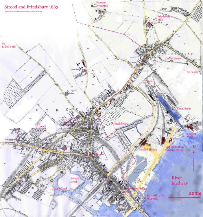
Amalgam of Strood and Frindsbury 1863 OS XIX 2 1st Edit, Hand coloured with line showing division between Frindsbury
|
||||
| Date | |||||
| Source | own work based on above, from Local Studies Centre, Strood. | ||||
| Author | Clem Rutter |
This work created by the United Kingdom Government is in the public domain.
This is because it is one of the following:
HMSO has declared that the expiry of Crown Copyrights applies worldwide (ref: HMSO Email Reply)
|
 |
Licensing
I, the copyright holder of this work, hereby publish it under the following licenses:

|
Permission is granted to copy, distribute and/or modify this document under the terms of the GNU Free Documentation License, Version 1.2 or any later version published by the Free Software Foundation; with no Invariant Sections, no Front-Cover Texts, and no Back-Cover Texts. A copy of the license is included in the section entitled GNU Free Documentation License. |
| This file is licensed under the Creative Commons Attribution-Share Alike 3.0 Unported license. | ||
| ||
| This licensing tag was added to this file as part of the GFDL licensing update. |
This file is licensed under the Creative Commons Attribution 2.5 Generic license.
- You are free:
- to share – to copy, distribute and transmit the work
- to remix – to adapt the work
- Under the following conditions:
- attribution – You must give appropriate credit, provide a link to the license, and indicate if changes were made. You may do so in any reasonable manner, but not in any way that suggests the licensor endorses you or your use.
You may select the license of your choice.
File history
Click on a date/time to view the file as it appeared at that time.
| Date/Time | Dimensions | User | Comment | |
|---|---|---|---|---|
| current | 12:21, 6 December 2006 | 702 × 749 (113 KB) | ClemRutter | {{Information |Description=Amalgam of Strood and Frindsbury 1863 OS XIX 2 1st Edit, Hand coloured with line showing division between Frindsbury |Source=own work based on above, from Local Studies Centre, Strood. |Date=5th Dec 2006 |Author=Clem Rutter |Per |
File usage
The following page uses this file: