File:1979fivestorms.png
Size of this preview: 800 × 409 pixels. Other resolutions: 320 × 164 pixels | 853 × 436 pixels.
Original file (853 × 436 pixels, file size: 633 KB, MIME type: image/png)
| This is a file from the Wikimedia Commons. The description on its description page there is shown below.
|
Summary
| Description |
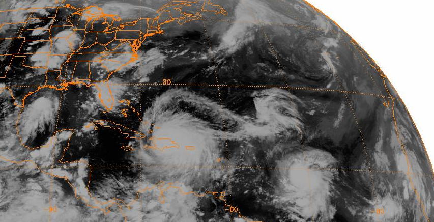
English: GIBBS Satellite image taken on September 1, 1979. From left to right, Tropical Storm Elena is located in the Gulf of Mexico, Hurricane David is centered over Hispaniola, Hurricane Frederic is located near 15°N 45°N, a tropical depression is dissipating south of Newfoundland, and another unnumbered tropical depression is adjacent to Africa near the coastlines of Senegal and Mauritania. |
| Date | |
| Source | http://www.ncdc.noaa.gov/gibbs/image/SMS-2/IR/1979-09-01-00 |
| Author | National Oceanic and Atmospheric Administration |
Licensing
This image is in the public domain because it contains materials that originally came from the U.S. National Oceanic and Atmospheric Administration, taken or made as part of an employee's official duties.
|
File history
Click on a date/time to view the file as it appeared at that time.
| Date/Time | Dimensions | User | Comment | |
|---|---|---|---|---|
| current | 20:32, 19 October 2012 | 853 × 436 (633 KB) | 12george1 | User created page with UploadWizard |
File usage
The following page uses this file: